IMAGES TAKEN NEAR TO
Selby Close, SHEFFIELD, S26 4NR
Introduction
This page details the photographs taken nearby to Selby Close, S26 4NR by members of the Geograph project.
The Geograph project started in 2005 with the aim of publishing, organising and preserving representative images for every square kilometre of Great Britain, Ireland and the Isle of Man.

There are currently over 7.5m images from over14,400 individuals and you can help contribute to the project by visiting https://www.geograph.org.uk
Image Map (Loading...)


Getting Data...Please wait
Leaflet Map data © OpenStreetMap
Images are licensed for reuse under creativecommons.org/licenses/by-sa/2.0
Notes
- Clicking on the map will re-center to the selected point.
- The higher the marker number, the further away the image location is from the centre of the postcode.
Image Listing (7 Images Found)
Images are licensed for reuse under creativecommons.org/licenses/by-sa/2.0
Image
Details
Distance
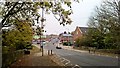
2
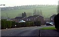
Swallownest - Wetherby Drive
Looking in an easterly direction from the main road to Swallownest.
Image: © Andrew Loughran
Taken: 24 Jan 2006
0.15 miles
4
Bethesda Church, Swallownest
On Mansfield Road, not long after a young man had died in a road traffic accident which is evidenced by many posters and floral tributes on this stretch of road.
Image: © Chris Morgan
Taken: 27 Oct 2015
0.22 miles
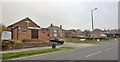
6
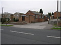
Bethesda Church
This small church is the Bethesda Pentecostal Church in Aston.
Image: © Michael Patterson
Taken: 2 May 2006
0.23 miles
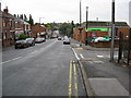
7
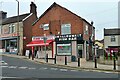
Meat or fish for tea today?
Butcher's and fish 'n chips shops in Swallownest
Image: © Graham Hogg
Taken: 27 Oct 2015
0.23 miles