IMAGES TAKEN NEAR TO
West Lane, SHEFFIELD, S26 3US
Introduction
This page details the photographs taken nearby to West Lane, S26 3US by members of the Geograph project.
The Geograph project started in 2005 with the aim of publishing, organising and preserving representative images for every square kilometre of Great Britain, Ireland and the Isle of Man.

There are currently over 7.5m images from over14,400 individuals and you can help contribute to the project by visiting https://www.geograph.org.uk
Image Map
Images are licensed for reuse under creativecommons.org/licenses/by-sa/2.0
Notes
- Clicking on the map will re-center to the selected point.
- The higher the marker number, the further away the image location is from the centre of the postcode.
Image Listing (7 Images Found)
Images are licensed for reuse under creativecommons.org/licenses/by-sa/2.0
Image
Details
Distance
2
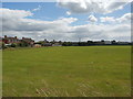
School Playing Field on the Fringes of Aughton
Pictured from West Lane.
Image: © Jonathan Clitheroe
Taken: 27 Jun 2016
0.15 miles
3
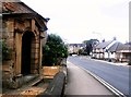
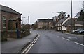
Aughton Village Centre
Several prominent buildings in the village can be seen here including the Robin Hood public house on the right.
Image: © Jonathan Clitheroe
Taken: 27 Jun 2016
0.17 miles
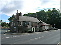
6
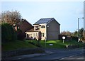
House on Ulley View, Aughton
Solar panels on roofs look so ugly. They are invariably add-ons, not anticipated in the house architect's vision. Environmentally and economically are they really as sensible and desirable as the advertising hype suggests?
Image: © Neil Theasby
Taken: 18 Nov 2012
0.23 miles
7
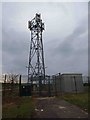
Telecoms mast on West Lane
Sited in the grounds of Aughton service reservoir.
Image: © Steve Fareham
Taken: 11 Jan 2009
0.24 miles