IMAGES TAKEN NEAR TO
Piper Lane, SHEFFIELD, S26 2EF
Introduction
This page details the photographs taken nearby to Piper Lane, S26 2EF by members of the Geograph project.
The Geograph project started in 2005 with the aim of publishing, organising and preserving representative images for every square kilometre of Great Britain, Ireland and the Isle of Man.

There are currently over 7.5m images from over14,400 individuals and you can help contribute to the project by visiting https://www.geograph.org.uk
Image Map
Images are licensed for reuse under creativecommons.org/licenses/by-sa/2.0
Notes
- Clicking on the map will re-center to the selected point.
- The higher the marker number, the further away the image location is from the centre of the postcode.
Image Listing (17 Images Found)
Images are licensed for reuse under creativecommons.org/licenses/by-sa/2.0
Image
Details
Distance

2
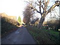
Public Footpath along Piper Lane, Aston
Image: © Jonathan Clitheroe
Taken: 7 Dec 2008
0.07 miles

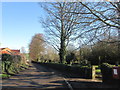
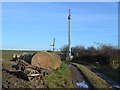
4
Piper Lane, Aston
A tractor is pulling a trailer loaded with bales of straw up the lane towards the village.
Image: © Neil Theasby
Taken: 3 Sep 2019
0.13 miles

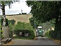
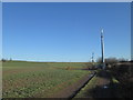
7
Mobile phone mast near New South Farm
The tower of All Saints Church, Aston is visible in the distance
Image: © John Slater
Taken: 17 Feb 2015
0.20 miles
10
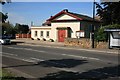
William Lane reading room
By the road junction of the B6067 and opposite a parade of shops.
Image: © roger geach
Taken: 22 Jun 2010
0.21 miles