IMAGES TAKEN NEAR TO
Judith Road, SHEFFIELD, S26 2BJ
Introduction
This page details the photographs taken nearby to Judith Road, S26 2BJ by members of the Geograph project.
The Geograph project started in 2005 with the aim of publishing, organising and preserving representative images for every square kilometre of Great Britain, Ireland and the Isle of Man.

There are currently over 7.5m images from over14,400 individuals and you can help contribute to the project by visiting https://www.geograph.org.uk
Image Map
Images are licensed for reuse under creativecommons.org/licenses/by-sa/2.0
Notes
- Clicking on the map will re-center to the selected point.
- The higher the marker number, the further away the image location is from the centre of the postcode.
Image Listing (8 Images Found)
Images are licensed for reuse under creativecommons.org/licenses/by-sa/2.0
Image
Details
Distance
5
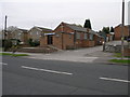
Bethesda Church
This small church is the Bethesda Pentecostal Church in Aston.
Image: © Michael Patterson
Taken: 2 May 2006
0.19 miles
6
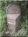
Old milestone
At the south end of Aston on the A618 southwards from Rotherham is this, in 2019, sad looking milestone desperately in need of refurbishment. This route was the southernmost road of the old West Riding that had the West Riding CC milestones set in place by the family firm of Gill & Frank Stead of Mirfield. There is a hole in the top of the stone for past use by the Ordnance Survey. This road had been turnpiked between 1764 and 1874. The milestone is Grade II listed 335887.
Image: © Chris Minto
Taken: 19 May 2019
0.20 miles
7
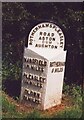
Old Milestone, on the A618, Mansfield Road, S end of Aston, 200m SE of junction with Lodge Lane
Located on the East side of road, near bus stop, opposite small industrial estate. Metal plate attached to stone post, Brayshaw & Booth casting design, 19th century.
Inscription reads: MANSFIELD / 17¼ MILES / PLEASLEY / 14¼ MILES / CLOWN / 6¾ MILES // ROTHERHAM / 6 MILES // ROTHERHAM & PLEASLEY / ROAD / ASTON / CUM / AUGHTON // BRAYSHAW & BOOTH / MAKERS / LIVERSEDGE
Grade II listed by Historic England. see https://historicengland.org.uk/listing/the-list/list-entry/1314656
Milestone Society National ID: YS_RMPL06
Image: © Christine Minto
Taken: 4 Jan 2006
0.21 miles
8
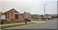
Bethesda Church, Swallownest
On Mansfield Road, not long after a young man had died in a road traffic accident which is evidenced by many posters and floral tributes on this stretch of road.
Image: © Chris Morgan
Taken: 27 Oct 2015
0.21 miles