IMAGES TAKEN NEAR TO
Aston Common, SHEFFIELD, S26 2AE
Introduction
This page details the photographs taken nearby to Aston Common, S26 2AE by members of the Geograph project.
The Geograph project started in 2005 with the aim of publishing, organising and preserving representative images for every square kilometre of Great Britain, Ireland and the Isle of Man.

There are currently over 7.5m images from over14,400 individuals and you can help contribute to the project by visiting https://www.geograph.org.uk
Image Map
Images are licensed for reuse under creativecommons.org/licenses/by-sa/2.0
Notes
- Clicking on the map will re-center to the selected point.
- The higher the marker number, the further away the image location is from the centre of the postcode.
Image Listing (14 Images Found)
Images are licensed for reuse under creativecommons.org/licenses/by-sa/2.0
Image
Details
Distance
2
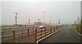
Separate traffic lights for horses and pedestrians
An elaborate staggered system to control horses and walkers in two separate crossings, with push buttons at different heights.
Image: © Chris Morgan
Taken: 27 Oct 2015
0.08 miles
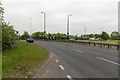
3
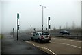
Crossing the A57 near Todwick
There are separate light controlled crossings here for pedestrians and horse riders. The timings allow horse riders to cross both carriageways at once while pedestrians have to wait and call the lights again in the central reservation.
According to the OS map the bridleway ends where it joins the A57. I'm not sure many riders would want to take their horse on this busy dual carriageway.
Image: © Graham Hogg
Taken: 27 Oct 2015
0.12 miles
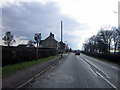
4
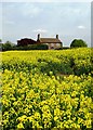
Conduit House Farm
Between Aston and Todwick
Image: © Neil Theasby
Taken: 5 May 2014
0.12 miles
5
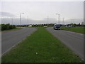
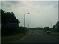
Junction 31
Junction 31 of the M1 viewed from the east. The street lights show the shape of the island even from this point of view.
Image: © Michael Patterson
Taken: 2 May 2006
0.17 miles
7
Goose Carr Lane
Heading north approaching the junction with the A57.
Image: © JThomas
Taken: 7 Mar 2015
0.21 miles
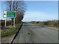
9
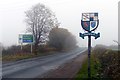
Todwick village sign on Goose Carr Lane
The shield is a recent innovation (dating from 2009) made up of elements that reflect significant historic landowners and the parish church. http://www.todwick.org.uk/village/history.html
Image: © Graham Hogg
Taken: 27 Oct 2015
0.22 miles
10
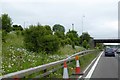
Traffic queueing at J31 on M1 southbound
The triangle of ground between the off slip road and the M1 is a mass of wild flowers and shrubs
Image: © David Smith
Taken: 20 Jun 2015
0.23 miles