IMAGES TAKEN NEAR TO
Sheffield Road, SHEFFIELD, S26 1DJ
Introduction
This page details the photographs taken nearby to Sheffield Road, S26 1DJ by members of the Geograph project.
The Geograph project started in 2005 with the aim of publishing, organising and preserving representative images for every square kilometre of Great Britain, Ireland and the Isle of Man.

There are currently over 7.5m images from over14,400 individuals and you can help contribute to the project by visiting https://www.geograph.org.uk
Image Map
Images are licensed for reuse under creativecommons.org/licenses/by-sa/2.0
Notes
- Clicking on the map will re-center to the selected point.
- The higher the marker number, the further away the image location is from the centre of the postcode.
Image Listing (12 Images Found)
Images are licensed for reuse under creativecommons.org/licenses/by-sa/2.0
Image
Details
Distance
4
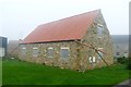
Temporary solution to a drainage problem
A barn conversion at Todwick Common Farm
Image: © Graham Hogg
Taken: 27 Oct 2015
0.09 miles
5
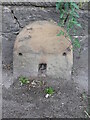
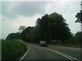
Old milestone
On the A57 between junction 31 of the M1 and Todwick cross-roads is the third in the sequence of milestones after Sheffield 8 and 9. Sheffield 10/Worksop 8. They may date from the turnpike era. The Worksop to Attercliffe turnpike was operative from 1764 to 1881. It was 16 miles long with 5 main gates and 3 side gates. The plate from this stone may have been removed in 1940. There is an OS pin in the top. It is Grade II listed 1151906.
Image: © Chris Minto
Taken: 15 Jul 2012
0.10 miles
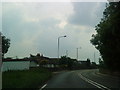
6
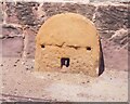
Old Milestone, on the A57, Worksop Road
Between J31 of M1 & Todwick X rds (Red Lion) 35m E of entrance to Todwick Grange. Located on the North side of road, on pavement, backing onto wall, surrounding Todwick Grange, nr lp55. Stone post (plate lost), 18th century.
Inscription reads: (SHEFFIELD / 10 / WORKSOP/ 8)
Grade II listed by Historic England. see https://historicengland.org.uk/listing/the-list/list-entry/1151906
Milestone Society National ID: YS_SFWS10
Image: © Christine Minto
Taken: 5 Jan 2006
0.11 miles