IMAGES TAKEN NEAR TO
City Road, SHEFFIELD, S2 5HQ
Introduction
This page details the photographs taken nearby to City Road, S2 5HQ by members of the Geograph project.
The Geograph project started in 2005 with the aim of publishing, organising and preserving representative images for every square kilometre of Great Britain, Ireland and the Isle of Man.

There are currently over 7.5m images from over14,400 individuals and you can help contribute to the project by visiting https://www.geograph.org.uk
Image Map
Images are licensed for reuse under creativecommons.org/licenses/by-sa/2.0
Notes
- Clicking on the map will re-center to the selected point.
- The higher the marker number, the further away the image location is from the centre of the postcode.
Image Listing (36 Images Found)
Images are licensed for reuse under creativecommons.org/licenses/by-sa/2.0
Image
Details
Distance
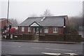
1

Junior school to restaurant
Change in use at former school on City Road, Manor Lane; Kebabish grill bar restaurant.
Image: © Peter Barr
Taken: 19 Jul 2011
0.03 miles

3

Former H W Roberts Memorial Works
On City Road, Sheffield.
Image: © Ian S
Taken: 18 Dec 2019
0.04 miles
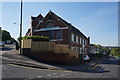
4

View of school on City Road from St Aidan's Road
The school, with stone bearing inscription "Girls' School" is under repair. The road to the right is Manor Lane.
Image: © Roger Templeman
Taken: 1 Feb 2011
0.04 miles
5
Castle Dental Practice on City Road, Sheffield
Image: © Ian S
Taken: 18 Dec 2019
0.04 miles
6
Bethel United Church of Jesus Christ
On City Road, Sheffield.
Image: © Ian S
Taken: 3 May 2014
0.05 miles


10

St Aidan's Church
This Church is on City Road
Image: © Keith Pitchforth
Taken: 15 Apr 2010
0.08 miles