IMAGES TAKEN NEAR TO
Pine Avenue, SHEFFIELD, S25 5HA
Introduction
This page details the photographs taken nearby to Pine Avenue, S25 5HA by members of the Geograph project.
The Geograph project started in 2005 with the aim of publishing, organising and preserving representative images for every square kilometre of Great Britain, Ireland and the Isle of Man.

There are currently over 7.5m images from over14,400 individuals and you can help contribute to the project by visiting https://www.geograph.org.uk
Image Map
Images are licensed for reuse under creativecommons.org/licenses/by-sa/2.0
Notes
- Clicking on the map will re-center to the selected point.
- The higher the marker number, the further away the image location is from the centre of the postcode.
Image Listing (10 Images Found)
Images are licensed for reuse under creativecommons.org/licenses/by-sa/2.0
Image
Details
Distance
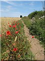
2
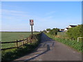
Bridleway towards Thorpe Salvin
This becomes First Lane but I'm not sure it is called that it this point
Image: © John Slater
Taken: 14 Apr 2012
0.19 miles
3
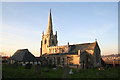
St.James church, South Anston
Mostly Decorated with a modern addition to the south.
Image: © Richard Croft
Taken: 23 Nov 2005
0.19 miles
5
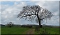
High Ash, South Anston
This lone ash tree is such a prominent feature just outside the village of South Anston in South Yorkshire that it gives its name to one of the streets there (High Ash Drive). It stands beside the bridleway leading down to the Chesterfield Canal and at the top of a hill known locally as "Mary Greaves".
Just beyond the brow of the hill (towards the next tree), the path begins its steep descent to the valley floor, switching through a gap in the hedgerow into a narrow field known as "Long Acre" (1 furlong long x 1 chain wide, or 220 yards x 22 yards). In the Middle Ages, an acre was defined as being the amount of land that could be ploughed in a day by one man and a yoke of oxen.
This image also appears on Flickr: https://www.flickr.com/photos/128783627@N03/29024784794/in/photostream/
Image: © Mike Nield
Taken: 9 Apr 2016
0.20 miles
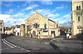
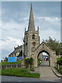
8
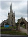
St James' Church and gateway, South Anston
A lovely church with a steeple set on a hill overlooking the main street through South Anston which is by-passed by the busy A57.
Image: © Andrew Hill
Taken: 4 Sep 2010
0.23 miles
9
St James Parish Church in South Anston
Image: © Mat Fascione
Taken: 22 May 2016
0.24 miles
10
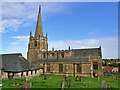
Church of St James
Grade I listed parish church dating from the 14th century
Image: © Graham Hogg
Taken: 26 Sep 2022
0.24 miles