IMAGES TAKEN NEAR TO
Manor Farm Gardens, SHEFFIELD, S25 5FS
Introduction
This page details the photographs taken nearby to Manor Farm Gardens, S25 5FS by members of the Geograph project.
The Geograph project started in 2005 with the aim of publishing, organising and preserving representative images for every square kilometre of Great Britain, Ireland and the Isle of Man.

There are currently over 7.5m images from over14,400 individuals and you can help contribute to the project by visiting https://www.geograph.org.uk
Image Map
Images are licensed for reuse under creativecommons.org/licenses/by-sa/2.0
Notes
- Clicking on the map will re-center to the selected point.
- The higher the marker number, the further away the image location is from the centre of the postcode.
Image Listing (36 Images Found)
Images are licensed for reuse under creativecommons.org/licenses/by-sa/2.0
Image
Details
Distance
1
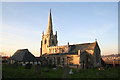
St.James church, South Anston
Mostly Decorated with a modern addition to the south.
Image: © Richard Croft
Taken: 23 Nov 2005
0.03 miles
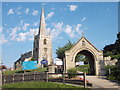
3
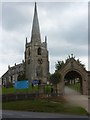
St James' Church and gateway, South Anston
A lovely church with a steeple set on a hill overlooking the main street through South Anston which is by-passed by the busy A57.
Image: © Andrew Hill
Taken: 4 Sep 2010
0.03 miles
4
St James Parish Church in South Anston
Image: © Mat Fascione
Taken: 22 May 2016
0.04 miles
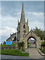
5
St James's Church, South Anston
There has been a place of worship in Anston since at least 1171 and St James's has survived the upheavals of civil war, poverty and sickness. The lovely limestone church you see today dates mostly from the 14th century, with the tower being added in the 15th century. The building has grown over the years to reflect the changing and expanding community and only a few stones, incorporated into the tower, remain of the original building.
Image: © Neil Theasby
Taken: 1 Aug 2013
0.04 miles
6
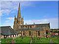
Church of St James
Grade I listed parish church dating from the 14th century
Image: © Graham Hogg
Taken: 26 Sep 2022
0.04 miles
7
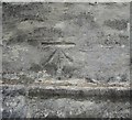
Ordnance Survey Cut Mark
This OS cut mark can be found on the west face of St James Church. It marks a point 116.196m above mean sea level.
Image: © Adrian Dust
Taken: 23 May 2016
0.05 miles
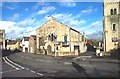
8
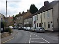
Sheffield Road, South Anston
Looking along the village street from a point near the Methodist church. There are a few shops and a couple of pubs.
Image: © Andrew Hill
Taken: 4 Sep 2010
0.05 miles
9

View from The Green, North Anston
Looking over the old village of North Anston towards St James Church, South Anston
Image: © Les Coe
Taken: 11 Jul 2012
0.05 miles
10

Evening cricket match at North Anston
An evening cricket match at North Anston, with St James Church, South Anston in the background.
Image: © Les Coe
Taken: 9 Jun 2012
0.05 miles