IMAGES TAKEN NEAR TO
Wesley Place, SHEFFIELD, S25 5DZ
Introduction
This page details the photographs taken nearby to Wesley Place, S25 5DZ by members of the Geograph project.
The Geograph project started in 2005 with the aim of publishing, organising and preserving representative images for every square kilometre of Great Britain, Ireland and the Isle of Man.

There are currently over 7.5m images from over14,400 individuals and you can help contribute to the project by visiting https://www.geograph.org.uk
Image Map
Images are licensed for reuse under creativecommons.org/licenses/by-sa/2.0
Notes
- Clicking on the map will re-center to the selected point.
- The higher the marker number, the further away the image location is from the centre of the postcode.
Image Listing (32 Images Found)
Images are licensed for reuse under creativecommons.org/licenses/by-sa/2.0
Image
Details
Distance
1
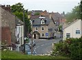
Village scene, South Anston
View down to Sheffield Road from the High Street.
Image: © Andrew Hill
Taken: 4 Sep 2010
0.03 miles
3
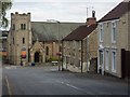
The end of West Street and the Methodist church
Looking down West Street to the Methodist church on Sheffield Road.
Image: © Andrew Hill
Taken: 4 Sep 2010
0.04 miles
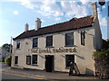
4

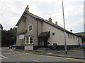
Leeds Arms
A community pub in the heart of the village.
Image: © Graham Hogg
Taken: 26 Sep 2022
0.04 miles
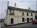
5
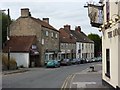
Sheffield Road, South Anston
Looking past the side of the Loyal Trooper pub to the row of shops on the other side of the road.
Image: © Andrew Hill
Taken: 4 Sep 2010
0.04 miles
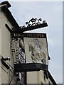
7
"The Loyal Trooper" public house in South Anston
Image: © Neil Theasby
Taken: 1 Aug 2013
0.05 miles

10
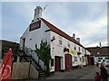
The Loyal Trooper pub, car park and surrounding building
Image: © Tom Page
Taken: 29 Oct 2021
0.06 miles