IMAGES TAKEN NEAR TO
Universal Crescent, SHEFFIELD, S25 4NZ
Introduction
This page details the photographs taken nearby to Universal Crescent, S25 4NZ by members of the Geograph project.
The Geograph project started in 2005 with the aim of publishing, organising and preserving representative images for every square kilometre of Great Britain, Ireland and the Isle of Man.

There are currently over 7.5m images from over14,400 individuals and you can help contribute to the project by visiting https://www.geograph.org.uk
Image Map
Images are licensed for reuse under creativecommons.org/licenses/by-sa/2.0
Notes
- Clicking on the map will re-center to the selected point.
- The higher the marker number, the further away the image location is from the centre of the postcode.
Image Listing (6 Images Found)
Images are licensed for reuse under creativecommons.org/licenses/by-sa/2.0
Image
Details
Distance
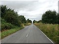
1

Dismantled Railway Bridge
The missing railway bridge carried a branch line over Common Road on its way to Thurcroft Colliery.
Image: © Michael Patterson
Taken: 3 Feb 2006
0.07 miles
2
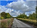
Drive to Bluebell Wood Children's Hospice
Off Cramfit Road in North Anston
Image: © Graham Hogg
Taken: 26 Sep 2022
0.13 miles
3
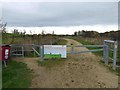
Gated entrance to Dinnington community woodland
Image: © Steve Fareham
Taken: 11 Nov 2014
0.14 miles
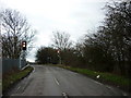
5
Common Road near North Anston
Looking towards the B6463 Todwick Road crossroads.
Image: © Jonathan Clitheroe
Taken: 16 Jul 2016
0.18 miles
6
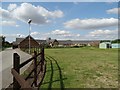
Bluebell Wood Children's Hospice
Largely funded by charitable donations. It amazes many people that these wonderful and vital institutions are not financially underwritten by national government or the NHS.
Image: © Neil Theasby
Taken: 22 Jul 2014
0.21 miles