IMAGES TAKEN NEAR TO
Elder Avenue, SHEFFIELD, S25 4GW
Introduction
This page details the photographs taken nearby to Elder Avenue, S25 4GW by members of the Geograph project.
The Geograph project started in 2005 with the aim of publishing, organising and preserving representative images for every square kilometre of Great Britain, Ireland and the Isle of Man.

There are currently over 7.5m images from over14,400 individuals and you can help contribute to the project by visiting https://www.geograph.org.uk
Image Map
Images are licensed for reuse under creativecommons.org/licenses/by-sa/2.0
Notes
- Clicking on the map will re-center to the selected point.
- The higher the marker number, the further away the image location is from the centre of the postcode.
Image Listing (2 Images Found)
Images are licensed for reuse under creativecommons.org/licenses/by-sa/2.0
Image
Details
Distance
1
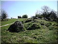
Anston Stones top path
The rocks seen to the right of the path are lumps of Permian dolomitic limestone. The outcrops were part of a 'coral garden' laid down when the area was covered by the Zechstein Sea.
Image: © Robin Stonebridge
Taken: 15 Apr 2007
0.23 miles