IMAGES TAKEN NEAR TO
Willow Chase, SHEFFIELD, S25 4DQ
Introduction
This page details the photographs taken nearby to Willow Chase, S25 4DQ by members of the Geograph project.
The Geograph project started in 2005 with the aim of publishing, organising and preserving representative images for every square kilometre of Great Britain, Ireland and the Isle of Man.

There are currently over 7.5m images from over14,400 individuals and you can help contribute to the project by visiting https://www.geograph.org.uk
Image Map
Images are licensed for reuse under creativecommons.org/licenses/by-sa/2.0
Notes
- Clicking on the map will re-center to the selected point.
- The higher the marker number, the further away the image location is from the centre of the postcode.
Image Listing (9 Images Found)
Images are licensed for reuse under creativecommons.org/licenses/by-sa/2.0
Image
Details
Distance
1
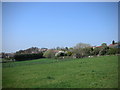
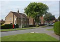
North Anston from the Stones Wood
Image: © Robin Stonebridge
Taken: 15 Apr 2007
0.08 miles
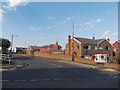
2
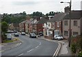
Ryton Road, North Anston
Ryton Road is the B6060 from Dinnington through North Anston towards the A57.
Image: © Andrew Hill
Taken: 4 Sep 2010
0.19 miles
3
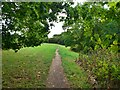
Public footpath
On a hillside to the north of Anston Brook
Image: © Graham Hogg
Taken: 26 Sep 2022
0.20 miles
4
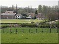
Anston Cricket field
This cricket field isn't 'near to Anston' it is in the village itself.
Image: © Robin Stonebridge
Taken: 15 Apr 2007
0.21 miles
5
Woodsetts Road, North Anston
The path through Windmill Wood reaches Woodsetts Road at this point.
Image: © Andrew Hill
Taken: 4 Sep 2010
0.22 miles
6
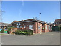
The parish hall in North Anston.
Good starting point for a walk.
Image: © steven ruffles
Taken: 17 Apr 2021
0.22 miles
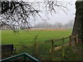
9
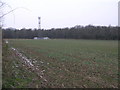
Communication Mast
What is hopefully the last snow of this winter still lies on the field margin. The communication mast stands circa 400ft above sea level at its base. If the mast is at least 50 feet tall then the top of it is the highest point looking east before continental Europe. The Lincolnshire Wolds due east top out at 443ft.
Image: © Michael Patterson
Taken: 7 Mar 2006
0.25 miles