IMAGES TAKEN NEAR TO
Sanctuary Fields, SHEFFIELD, S25 4DD
Introduction
This page details the photographs taken nearby to Sanctuary Fields, S25 4DD by members of the Geograph project.
The Geograph project started in 2005 with the aim of publishing, organising and preserving representative images for every square kilometre of Great Britain, Ireland and the Isle of Man.

There are currently over 7.5m images from over14,400 individuals and you can help contribute to the project by visiting https://www.geograph.org.uk
Image Map
Images are licensed for reuse under creativecommons.org/licenses/by-sa/2.0
Notes
- Clicking on the map will re-center to the selected point.
- The higher the marker number, the further away the image location is from the centre of the postcode.
Image Listing (4 Images Found)
Images are licensed for reuse under creativecommons.org/licenses/by-sa/2.0
Image
Details
Distance
1
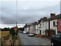
Springfield Terrace on Cramfit Lane
Situated on the western outskirts of North Anston.
Image: © Jonathan Clitheroe
Taken: 16 Jul 2016
0.16 miles
2
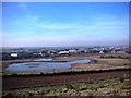
The Bird Scrape, North Anston
This photograph was taken from the top of the reclaimed Dinnington colliery site. The bird scrape was the idea of the SK58 Birders Group, and there is now a hide close by to watch wading birds.
Image: © Robin Stonebridge
Taken: 10 Feb 2008
0.21 miles
3
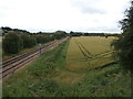
Twin Track Freight Line near Anston
This railway line originally connected Doncaster and Worksop but hasn't carried passengers since 1929. It remains open to freight traffic and is viewed here from Cramfit bridge.
Image: © Jonathan Clitheroe
Taken: 16 Jul 2016
0.23 miles
4
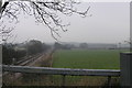
Railway Branch Line
This branch line joins the Sheffield to Lincoln line 3 miles from this point. the line heads north to Doncaster and before there it branches off again to Harworth Colliery.
Image: © Michael Patterson
Taken: 3 Feb 2006
0.23 miles