IMAGES TAKEN NEAR TO
Common Road, SHEFFIELD, S25 4AH
Introduction
This page details the photographs taken nearby to Common Road, S25 4AH by members of the Geograph project.
The Geograph project started in 2005 with the aim of publishing, organising and preserving representative images for every square kilometre of Great Britain, Ireland and the Isle of Man.

There are currently over 7.5m images from over14,400 individuals and you can help contribute to the project by visiting https://www.geograph.org.uk
Image Map
Images are licensed for reuse under creativecommons.org/licenses/by-sa/2.0
Notes
- Clicking on the map will re-center to the selected point.
- The higher the marker number, the further away the image location is from the centre of the postcode.
Image Listing (3 Images Found)
Images are licensed for reuse under creativecommons.org/licenses/by-sa/2.0
Image
Details
Distance
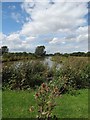
2
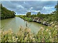
Pond in Straight Mile Fisheries
A purpose-built fishery off Common Road
Image: © Graham Hogg
Taken: 26 Sep 2022
0.09 miles
3
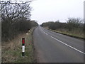
Straight Mile
Known locally as Brampton straight mile this road is very straight and measures 1.1 miles! Under proposed EU rules the new name will be Brampton straight 1.6 kilometres, or 1.77 to be precise.
Image: © Michael Patterson
Taken: 7 Mar 2006
0.23 miles