IMAGES TAKEN NEAR TO
Frankham Close, SHEFFIELD, S25 3QG
Introduction
This page details the photographs taken nearby to Frankham Close, S25 3QG by members of the Geograph project.
The Geograph project started in 2005 with the aim of publishing, organising and preserving representative images for every square kilometre of Great Britain, Ireland and the Isle of Man.

There are currently over 7.5m images from over14,400 individuals and you can help contribute to the project by visiting https://www.geograph.org.uk
Image Map
Images are licensed for reuse under creativecommons.org/licenses/by-sa/2.0
Notes
- Clicking on the map will re-center to the selected point.
- The higher the marker number, the further away the image location is from the centre of the postcode.
Image Listing (9 Images Found)
Images are licensed for reuse under creativecommons.org/licenses/by-sa/2.0
Image
Details
Distance
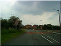
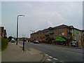
2
Number 19 bus to Worksop, Laughton Common
Image: © Mark Anderson
Taken: 23 May 2018
0.11 miles
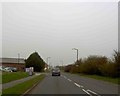
6
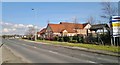
Monk's Bridge Farm, Laughton Common
A substantial family pub and restaurant from the Cloverleaf chain, part of Greene King from Bury St Edmunds.
Image: © Chris Morgan
Taken: 3 Mar 2014
0.22 miles
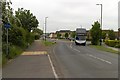
7
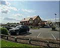
"Monks Bridge Farm" pub-restaurant
Between Laughton Common and Dinnington
Image: © Neil Theasby
Taken: 22 Jul 2014
0.22 miles
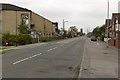
8
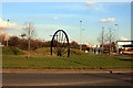
Monk's Bridge Roundabout
On the roundabout is a colliery winding wheel, presumably from nearby Dinnington Colliery which closed in 1992.
Image: © Graham Hogg
Taken: 3 Mar 2014
0.25 miles