IMAGES TAKEN NEAR TO
Barrow Way, SHEFFIELD, S25 3AB
Introduction
This page details the photographs taken nearby to Barrow Way, S25 3AB by members of the Geograph project.
The Geograph project started in 2005 with the aim of publishing, organising and preserving representative images for every square kilometre of Great Britain, Ireland and the Isle of Man.

There are currently over 7.5m images from over14,400 individuals and you can help contribute to the project by visiting https://www.geograph.org.uk
Image Map (Loading...)


Getting Data...Please wait
Leaflet Map data © OpenStreetMap
Images are licensed for reuse under creativecommons.org/licenses/by-sa/2.0
Notes
- Clicking on the map will re-center to the selected point.
- The higher the marker number, the further away the image location is from the centre of the postcode.
Image Listing (8 Images Found)
Images are licensed for reuse under creativecommons.org/licenses/by-sa/2.0
Image
Details
Distance
1
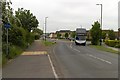
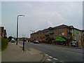
Number 19 bus to Worksop, Laughton Common
Image: © Mark Anderson
Taken: 23 May 2018
0.07 miles
7
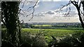
View towards Laughton Common from the hill
Laughton en le Morthen sits on top of a commanding hill - commanding all the better in times gone by with a motte and bailey castle and a soaring church spire visible from many miles away.
Today the coal mining industry that used to dominate the surrounding landscape has gone and light industry is gradually taking its place. Farming enjoys fertile conditions for arable crops.
Image: © Chris Morgan
Taken: 3 Mar 2014
0.18 miles