IMAGES TAKEN NEAR TO
S25 2WT
Introduction
This page details the photographs taken nearby to S25 2WT by members of the Geograph project.
The Geograph project started in 2005 with the aim of publishing, organising and preserving representative images for every square kilometre of Great Britain, Ireland and the Isle of Man.

There are currently over 7.5m images from over14,400 individuals and you can help contribute to the project by visiting https://www.geograph.org.uk
Image Map
Images are licensed for reuse under creativecommons.org/licenses/by-sa/2.0
Notes
- Clicking on the map will re-center to the selected point.
- The higher the marker number, the further away the image location is from the centre of the postcode.
Image Listing (11 Images Found)
Images are licensed for reuse under creativecommons.org/licenses/by-sa/2.0
Image
Details
Distance
1
Throapham House
A Bed and Breakfast establishment.
Image: © Graham Hogg
Taken: 3 Mar 2014
0.19 miles
2

"When You Make a Choice..."
"...There is Always a Consequence!". Small classroom in Seagrave House, Dinnington Comprehensive School.
Image: © Neil Theasby
Taken: 12 Aug 2014
0.21 miles
3
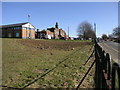
College Buildings
The Rother Valley Campus in Dinnington is part of Rotherham College of Arts and Technology. Note the new and old style of building.
Image: © Michael Patterson
Taken: 1 Mar 2006
0.22 miles
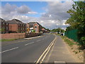
4
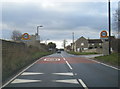
B6463 Oldcotes Road at Throapham village boundary
Image: © Colin Pyle
Taken: 2 Feb 2019
0.22 miles
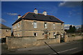
5
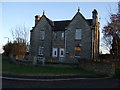
Throapham Lodge
The gate house to Throapham Manor.
Image: © John Poyser
Taken: 10 Jan 2007
0.22 miles
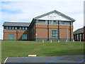
7

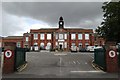
Chelmsford Mining Institute (Rother Valley College)
Dinnington Colliery was sunk in around 1905 which was to the left of the picture. In 1928 Viscount Chelmsford opened the college. Viscount Chelmsford was chairman of the Miner's Welfare Central Committee.
Image: © Martin Lee
Taken: 21 Jan 2012
0.22 miles
8
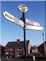
Direction Sign ? Signpost
Located on the northwest side of the mini roundabout at the junction of Outgang Lane and Breck Lane in Dinnington St Johns parish. 4 arms, 1 worboys, and annulus & bar finial.
Milestone Society National ID: YW_SK5286
Image: © C Minto
Taken: 6 Jan 2019
0.23 miles