IMAGES TAKEN NEAR TO
Western Avenue, SHEFFIELD, S25 2SL
Introduction
This page details the photographs taken nearby to Western Avenue, S25 2SL by members of the Geograph project.
The Geograph project started in 2005 with the aim of publishing, organising and preserving representative images for every square kilometre of Great Britain, Ireland and the Isle of Man.

There are currently over 7.5m images from over14,400 individuals and you can help contribute to the project by visiting https://www.geograph.org.uk
Image Map
Images are licensed for reuse under creativecommons.org/licenses/by-sa/2.0
Notes
- Clicking on the map will re-center to the selected point.
- The higher the marker number, the further away the image location is from the centre of the postcode.
Image Listing (7 Images Found)
Images are licensed for reuse under creativecommons.org/licenses/by-sa/2.0
Image
Details
Distance
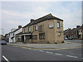
1
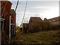
Dinnington dereliction
Near St Leonard's Church.
Image: © Steve Fareham
Taken: 22 Dec 2008
0.03 miles
3
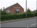
St Joseph's
This modern looking brick built church is the Roman Catholic Church of St Joseph's in Dinnington.
Image: © Michael Patterson
Taken: 6 Jun 2006
0.13 miles
5
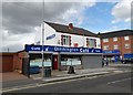
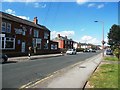
Dinnington Caf
The accent on Café is important as it highlights the sophistication of this establishment on Lordens Hill, Dinnington.
Image: © Neil Theasby
Taken: 12 Aug 2014
0.22 miles
6

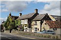
The Venus viewed from New Road
In summer the walls are coloured red with the plants growing on them
Image: © Martin Lee
Taken: 21 Jan 2012
0.24 miles