IMAGES TAKEN NEAR TO
Leys Lane, SHEFFIELD, S25 2QA
Introduction
This page details the photographs taken nearby to Leys Lane, S25 2QA by members of the Geograph project.
The Geograph project started in 2005 with the aim of publishing, organising and preserving representative images for every square kilometre of Great Britain, Ireland and the Isle of Man.

There are currently over 7.5m images from over14,400 individuals and you can help contribute to the project by visiting https://www.geograph.org.uk
Image Map (Loading...)


Getting Data...Please wait
Leaflet Map data © OpenStreetMap
Images are licensed for reuse under creativecommons.org/licenses/by-sa/2.0
Notes
- Clicking on the map will re-center to the selected point.
- The higher the marker number, the further away the image location is from the centre of the postcode.
Image Listing (8 Images Found)
Images are licensed for reuse under creativecommons.org/licenses/by-sa/2.0
Image
Details
Distance
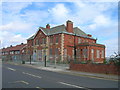
4
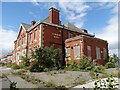
"The Lordens Hotel", Dinnington
Once a bustling pub filled with thirsty coal miners and their families but now a dilapidated monument to times past.
Image: © Neil Theasby
Taken: 12 Aug 2014
0.04 miles
5
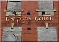
"The Lordens Hotel" in Dinnington
Now disused, the unmaintained lettering speaks of the place's dereliction.
Image: © Neil Theasby
Taken: 12 Aug 2014
0.04 miles
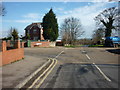
6
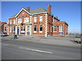
Lordens Hotel
Other than a 'missing' chimney Lordens Hotel displays some impressive symmetry.
Image: © Michael Patterson
Taken: 1 Mar 2006
0.07 miles
7
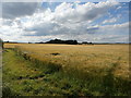
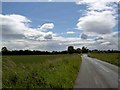
Fields and Coppice seen from Ley Lane
Beyond the field of barley is the Lime Kiln Close Plantation.
Image: © Jonathan Clitheroe
Taken: 18 Jul 2016
0.14 miles