IMAGES TAKEN NEAR TO
Lancing Road, SHEFFIELD, S2 4ES
Introduction
This page details the photographs taken nearby to Lancing Road, S2 4ES by members of the Geograph project.
The Geograph project started in 2005 with the aim of publishing, organising and preserving representative images for every square kilometre of Great Britain, Ireland and the Isle of Man.

There are currently over 7.5m images from over14,400 individuals and you can help contribute to the project by visiting https://www.geograph.org.uk
Image Map
Images are licensed for reuse under creativecommons.org/licenses/by-sa/2.0
Notes
- Clicking on the map will re-center to the selected point.
- The higher the marker number, the further away the image location is from the centre of the postcode.
Image Listing (220 Images Found)
Images are licensed for reuse under creativecommons.org/licenses/by-sa/2.0
Image
Details
Distance
1
Benchmark on building on Edmund Road
Ordnance Survey cut mark benchmark described on the Bench Mark Database at http://www.bench-marks.org.uk/bm39577
Image: © Roger Templeman
Taken: 19 Sep 2011
0.04 miles
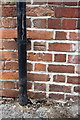
2
Premises of 'access techniques ltd', Edmund Road
The company offers rope access techniques training. There is an OS benchmark Image on the wall by the black downpipe.
Image: © Roger Templeman
Taken: 19 Sep 2011
0.05 miles
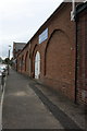
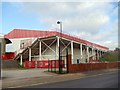
3
Shoreham Street, Sheffield
Looking down Shoreham Street, Sheffield United's Bramall Lane ground is behind the brick wall on the right.
Image: © Graham Robson
Taken: 25 Jun 2017
0.05 miles
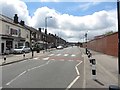
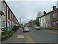
4
Sheffield: Shoreham Street Post Office
Situated on the corner of Shoreham Street and the cobbled Midland Street which we see ahead of us.
Image: © Chris Downer
Taken: 29 Apr 2009
0.07 miles
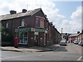
5
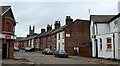
A Sheffield street scene
A cobbled Midland Street viewed from Shoreham Street.
Image: © Bobby Clegg
Taken: 20 Jul 2015
0.08 miles
6

River Sheaf from Duchess Road, Sheffield
The river is hard by an old industrial building, now business premises. The weir is shown on the 1:25,000 map.
Image: © Andrew Hill
Taken: 4 Apr 2012
0.09 miles
7
Looking from Countess Road into John Street
With Bramall Lane in view http://en.wikipedia.org/wiki/Bramall_Lane
Image: © Basher Eyre
Taken: 3 Apr 2012
0.10 miles
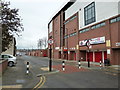
8
View of Bramall Lane Football ground from Shoreham Street
Image: © Bill Henderson
Taken: 19 Sep 2011
0.11 miles
10
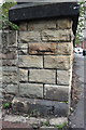
Benchmark on bridge parapet end, Duchess Road
Ordnance Survey cut mark benchmark described on the Bench Mark Database at http://www.bench-marks.org.uk/bm39579
Image: © Roger Templeman
Taken: 19 Sep 2011
0.11 miles