IMAGES TAKEN NEAR TO
Norfolk Road, SHEFFIELD, S2 2SY
Introduction
This page details the photographs taken nearby to Norfolk Road, S2 2SY by members of the Geograph project.
The Geograph project started in 2005 with the aim of publishing, organising and preserving representative images for every square kilometre of Great Britain, Ireland and the Isle of Man.

There are currently over 7.5m images from over14,400 individuals and you can help contribute to the project by visiting https://www.geograph.org.uk
Image Map
Images are licensed for reuse under creativecommons.org/licenses/by-sa/2.0
Notes
- Clicking on the map will re-center to the selected point.
- The higher the marker number, the further away the image location is from the centre of the postcode.
Image Listing (92 Images Found)
Images are licensed for reuse under creativecommons.org/licenses/by-sa/2.0
Image
Details
Distance
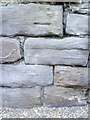
1
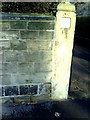
Benchmark on wall near entrance to #49 Norfolk Road
Ordnance Survey cut mark benchmark described on the Bench Mark Database at http://www.bench-marks.org.uk/bm36656
Image: © Roger Templeman
Taken: 1 Feb 2011
0.03 miles
2
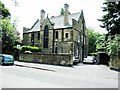
Sale Memorial Vicarage, Norfolk Road
The church was originally called St Luke's Dyers Hill, South Street and built in 1879; closed 1940 after being badly damaged in the blitz eventually demolished.
Image: © Stanley Walker
Taken: 15 Jun 2010
0.07 miles
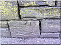
3

Benchmark on wall of Norfolk Road at its junction with Fitzwalter Road
Ordnance Survey cut mark benchmark described on the Bench Mark Database at http://www.bench-marks.org.uk/bm36657
Image: © Roger Templeman
Taken: 1 Feb 2011
0.08 miles
4
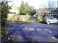
Gated entrance to Almshouses, Norfolk Road
Photograph taken from NE end of Belmonte Gardens showing junction with Norfolk Road.
Image: © Roger Templeman
Taken: 1 Feb 2011
0.09 miles
5
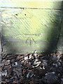
Benchmark on roadside wall pier of almshouses, Norfolk Road
Ordnance Survey cut mark benchmark described on the Bench Mark Database at http://www.bench-marks.org.uk/bm36655
Image: © Roger Templeman
Taken: 1 Feb 2011
0.09 miles
7
Benchmark on wall of Fitzwalter Road opposite Claywood Road
Ordnance Survey cut mark benchmark described on the Bench Mark Database at http://www.bench-marks.org.uk/bm36697
Image: © Roger Templeman
Taken: 1 Feb 2011
0.10 miles
9
Benchmark on the wall of Granville Road opposite #191
Ordnance Survey cut mark benchmark described on the Bench Mark Database at http://www.bench-marks.org.uk/bm36700
Image: © Roger Templeman
Taken: 1 Feb 2011
0.10 miles
10
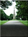
Cholera Monument, Norfolk Road
Built in 1834-5 by M.E.Hadfield and stands in the burial ground of 402 victims of the epidemic of 1832
Image: © Stanley Walker
Taken: 17 Jun 2010
0.11 miles