IMAGES TAKEN NEAR TO
Stafford Road, SHEFFIELD, S2 2SG
Introduction
This page details the photographs taken nearby to Stafford Road, S2 2SG by members of the Geograph project.
The Geograph project started in 2005 with the aim of publishing, organising and preserving representative images for every square kilometre of Great Britain, Ireland and the Isle of Man.

There are currently over 7.5m images from over14,400 individuals and you can help contribute to the project by visiting https://www.geograph.org.uk
Image Map
Images are licensed for reuse under creativecommons.org/licenses/by-sa/2.0
Notes
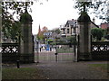
- Clicking on the map will re-center to the selected point.
- The higher the marker number, the further away the image location is from the centre of the postcode.
Image Listing (53 Images Found)
Images are licensed for reuse under creativecommons.org/licenses/by-sa/2.0
Image
Details
Distance
1
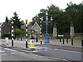
Granville Road Crossing
The Lantern outside this entrance to the Norfolk Heritage Park was moved from the bottom of Granville Road in 1904.
Image: © David Rogers
Taken: 26 Oct 2009
0.01 miles
2
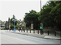
Norfolk Park, Granville Road Entrance
Lodge built in 1851 screen wall 1876
Image: © Stanley Walker
Taken: 18 Jun 2010
0.02 miles
3
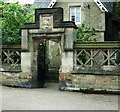
Norfolk Park Lodge entrance, Granville Road
Image: © Stanley Walker
Taken: 18 Jun 2010
0.04 miles
4
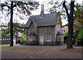
Norfolk Heritage Park, Sheffield
The Granville Road Lodge, built c.1841, was originally the Head Gardener's house. The gates and the stonework at this entrance to the park were not erected until 1876, just after Granville Road was constructed.
Image: © David Rogers
Taken: 26 Oct 2009
0.04 miles
5
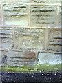
Benchmark on wall of outbuilding on Stafford Road
Ordnance Survey cut mark benchmark described on the Bench Mark Database at http://www.bench-marks.org.uk/bm36683
Image: © Roger Templeman
Taken: 1 Feb 2011
0.04 miles
6
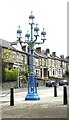
Victorian Gothic iron gas lamp, Norfolk Park
Image: © Stanley Walker
Taken: 18 Jun 2010
0.04 miles
7
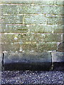
Benchmark on wall of disused public convenience at Granville Road entrance to Norfolk Park
Ordnance Survey cut mark benchmark described on the Bench Mark Database at http://www.bench-marks.org.uk/bm36676
Image: © Roger Templeman
Taken: 1 Feb 2011
0.05 miles
8
The Lantern
At the Granville Road entrance to Norfolk Heritage Park. The Lantern originally stood at the bottom of Granville Road and was moved to its present position in 1904. Now converted to electricity it was designed to ran on gas.
Image: © David Rogers
Taken: 26 Oct 2009
0.06 miles
9
Norfolk Heritage Park, Sheffield
The Granville Road gates; looking past The Lantern and up Stafford Road towards the spire of Victoria Methodist Church (Victoria Community Enterprises Ltd).
Image: © David Rogers
Taken: 26 Oct 2009
0.06 miles
10
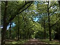
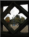
Norfolk Park, Sheffield. The Oak Avenue beyond Granville Road Gates
Norfolk Park was once a private deer park owned by the Duke of Norfolk who has historically had long associations with Sheffield. This majestic sylvan avenue was planted in 1840.
Image: © Neil Theasby
Taken: 30 May 2010
0.07 miles