1
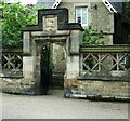
Granville Road Crossing
The Lantern outside this entrance to the Norfolk Heritage Park was moved from the bottom of Granville Road in 1904.
Image: © David Rogers
Taken: 26 Oct 2009
0.05 miles
2
Norfolk Park Lodge entrance, Granville Road
Image: © Stanley Walker
Taken: 18 Jun 2010
0.06 miles
3
Norfolk Park, Granville Road Entrance
Lodge built in 1851 screen wall 1876
Image: © Stanley Walker
Taken: 18 Jun 2010
0.06 miles
4
Benchmark on wall at entrance to #281 Granville Road
Ordnance Survey cut mark benchmark described on the Bench Mark Database at http://www.bench-marks.org.uk/bm36675
Image: © Roger Templeman
Taken: 1 Feb 2011
0.06 miles
5
Victorian Gothic iron gas lamp, Norfolk Park
Image: © Stanley Walker
Taken: 18 Jun 2010
0.06 miles
6
Norfolk Heritage Park, Sheffield
The Granville Road Lodge, built c.1841, was originally the Head Gardener's house. The gates and the stonework at this entrance to the park were not erected until 1876, just after Granville Road was constructed.
Image: © David Rogers
Taken: 26 Oct 2009
0.07 miles
7
Benchmark on wall of outbuilding on Stafford Road
Ordnance Survey cut mark benchmark described on the Bench Mark Database at http://www.bench-marks.org.uk/bm36683
Image: © Roger Templeman
Taken: 1 Feb 2011
0.07 miles
8
Benchmark on gatepost at entrance to #199 City Road
Ordnance Survey cut mark benchmark described on the Bench Mark Database at http://www.bench-marks.org.uk/bm36673
Image: © Roger Templeman
Taken: 1 Feb 2011
0.08 miles
9
Benchmark on wall of disused public convenience at Granville Road entrance to Norfolk Park
Ordnance Survey cut mark benchmark described on the Bench Mark Database at http://www.bench-marks.org.uk/bm36676
Image: © Roger Templeman
Taken: 1 Feb 2011
0.08 miles
10
Granville Road at Holdings Road, Sheffield
Image: © Ian S
Taken: 18 Dec 2019
0.09 miles


