IMAGES TAKEN NEAR TO
Snowdon Lane, SHEFFIELD, S21 5RT
Introduction
This page details the photographs taken nearby to Snowdon Lane, S21 5RT by members of the Geograph project.
The Geograph project started in 2005 with the aim of publishing, organising and preserving representative images for every square kilometre of Great Britain, Ireland and the Isle of Man.

There are currently over 7.5m images from over14,400 individuals and you can help contribute to the project by visiting https://www.geograph.org.uk
Image Map (Loading...)


Getting Data...Please wait
Leaflet Map data © OpenStreetMap
Images are licensed for reuse under creativecommons.org/licenses/by-sa/2.0
Notes
- Clicking on the map will re-center to the selected point.
- The higher the marker number, the further away the image location is from the centre of the postcode.
Image Listing (7 Images Found)
Images are licensed for reuse under creativecommons.org/licenses/by-sa/2.0
Image
Details
Distance
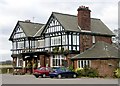
1
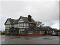
The Inn at Troway
Not actually at Troway but I suppose it sounds better than The Inn at the end of the lane to Troway.
Image: © John Slater
Taken: 19 Feb 2014
0.11 miles
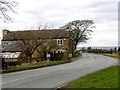
2
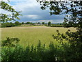
Across a field to a roadside pub
The road is the B6056, Coal Aston to Marsh Lane.
Image: © Peter Barr
Taken: 29 Jun 2011
0.11 miles
5
Black A'Moor Inn near Troway in NE Derbyshire
Image: © Andrew Loughran
Taken: 26 Jan 2006
0.12 miles
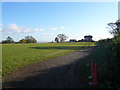
6
Snowden Farm, Troway, NE Derbyshire
View from the car park of the Black A'Moor Inn on Snowden Lane looking north towards Coal Aston & Sheffield.
Image: © Andrew Loughran
Taken: 26 Jan 2006
0.12 miles
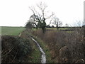
7
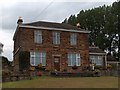
Leicester Villa Farmhouse, near Troway
Image: © Neil Theasby
Taken: 21 Sep 2010
0.20 miles