IMAGES TAKEN NEAR TO
School Lane, SHEFFIELD, S21 5RS
Introduction
This page details the photographs taken nearby to School Lane, S21 5RS by members of the Geograph project.
The Geograph project started in 2005 with the aim of publishing, organising and preserving representative images for every square kilometre of Great Britain, Ireland and the Isle of Man.

There are currently over 7.5m images from over14,400 individuals and you can help contribute to the project by visiting https://www.geograph.org.uk
Image Map
Images are licensed for reuse under creativecommons.org/licenses/by-sa/2.0
Notes
- Clicking on the map will re-center to the selected point.
- The higher the marker number, the further away the image location is from the centre of the postcode.
Image Listing (25 Images Found)
Images are licensed for reuse under creativecommons.org/licenses/by-sa/2.0
Image
Details
Distance
4
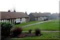
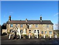
Warren Walk, Marsh Lane, Nr Eckington in NE Derbyshire
Old people's bungalows.
Image: © Andrew Loughran
Taken: 14 Feb 2006
0.11 miles
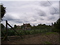
5
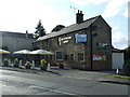
The Butchers Arms, Marsh Lane
On Main Road.
Image: © JThomas
Taken: 28 Aug 2014
0.13 miles

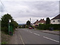
9
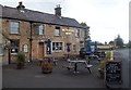
Public House and War Memorial in Marsh Lane
Pictured here at the junction with Ford Road on a dull Friday afternoon in late September. Good beer in the pub today.
Image: © Jonathan Clitheroe
Taken: 21 Sep 2012
0.16 miles
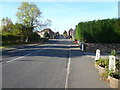
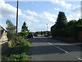
10
Marsh Lane - Approaching from Coal Aston Direction
Main Road (B6056) view.
Image: © Alan Heardman
Taken: 18 Oct 2007
0.16 miles