IMAGES TAKEN NEAR TO
Laurel Close, SHEFFIELD, S21 4JD
Introduction
This page details the photographs taken nearby to Laurel Close, S21 4JD by members of the Geograph project.
The Geograph project started in 2005 with the aim of publishing, organising and preserving representative images for every square kilometre of Great Britain, Ireland and the Isle of Man.

There are currently over 7.5m images from over14,400 individuals and you can help contribute to the project by visiting https://www.geograph.org.uk
Image Map
Images are licensed for reuse under creativecommons.org/licenses/by-sa/2.0
Notes
- Clicking on the map will re-center to the selected point.
- The higher the marker number, the further away the image location is from the centre of the postcode.
Image Listing (15 Images Found)
Images are licensed for reuse under creativecommons.org/licenses/by-sa/2.0
Image
Details
Distance
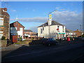
3

West End Pub, West Street, Eckington in NE Derbyshire
Image: © Andrew Loughran
Taken: 3 Sep 2006
0.17 miles
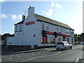
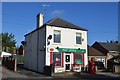
4

The former West End
Now the Hollinsend Convenience Store, on West Street, at junction with Fanshaw Road.
Image: © Peter Barr
Taken: 11 Jul 2012
0.19 miles
5
Convenience store, Eckington
On West Street.
Image: © JThomas
Taken: 28 Aug 2014
0.20 miles
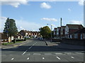
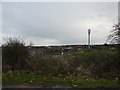
7

Junction of Dronfield and Chesterfield Roads at Eckington
Image: © Chris Morgan
Taken: 11 Dec 2013
0.21 miles
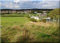
9
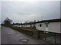
Prefabs in Eckington
Houses on Pipeyard Lane.
Image: © Peter Barr
Taken: 2 Jan 2013
0.22 miles