IMAGES TAKEN NEAR TO
Rectory Close, SHEFFIELD, S21 4GL
Introduction
This page details the photographs taken nearby to Rectory Close, S21 4GL by members of the Geograph project.
The Geograph project started in 2005 with the aim of publishing, organising and preserving representative images for every square kilometre of Great Britain, Ireland and the Isle of Man.

There are currently over 7.5m images from over14,400 individuals and you can help contribute to the project by visiting https://www.geograph.org.uk
Image Map
Images are licensed for reuse under creativecommons.org/licenses/by-sa/2.0
Notes
- Clicking on the map will re-center to the selected point.
- The higher the marker number, the further away the image location is from the centre of the postcode.
Image Listing (48 Images Found)
Images are licensed for reuse under creativecommons.org/licenses/by-sa/2.0
Image
Details
Distance
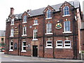
1
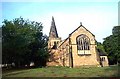
Eckington, Derbyshire, St Peter and St Paul's Church
See http://www.openchurchestrust.org.uk/Eckington.htm
Image: © Bill Henderson
Taken: Unknown
0.07 miles
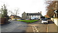
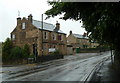
2
Church Street, Eckington
View from the edge of the churchyard.
Image: © Andrew Hill
Taken: 6 Oct 2012
0.07 miles
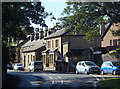
6
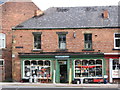
Eckington - French's Ironmongers Shop
On Station Road.
Image: © Dave Bevis
Taken: 24 Jul 2009
0.08 miles
7
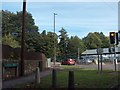
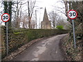
Junction of the B6053 and A6135 in Eckington
Image: © Neil Theasby
Taken: 2 Oct 2010
0.09 miles
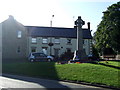
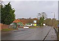
9
Church Street and the Prince of Wales pub, Eckington
Looking past the junction with Peveril Road on the left to the pub at the junction. The road is the B6052.
Image: © Andrew Hill
Taken: 30 May 2011
0.10 miles