IMAGES TAKEN NEAR TO
Hunsdon, SHEFFIELD, S21 4GG
Introduction
This page details the photographs taken nearby to Hunsdon, S21 4GG by members of the Geograph project.
The Geograph project started in 2005 with the aim of publishing, organising and preserving representative images for every square kilometre of Great Britain, Ireland and the Isle of Man.

There are currently over 7.5m images from over14,400 individuals and you can help contribute to the project by visiting https://www.geograph.org.uk
Image Map
Images are licensed for reuse under creativecommons.org/licenses/by-sa/2.0
Notes
- Clicking on the map will re-center to the selected point.
- The higher the marker number, the further away the image location is from the centre of the postcode.
Image Listing (21 Images Found)
Images are licensed for reuse under creativecommons.org/licenses/by-sa/2.0
Image
Details
Distance
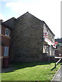
1
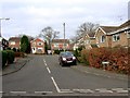
Greenfields, off Greenhall Road, Eckington, NE Derbyshire
Image: © Andrew Loughran
Taken: 26 Jan 2006
0.06 miles
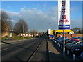
2
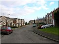
Greenhall Road, Eckington, NE Derbyshire
Image: © Andrew Loughran
Taken: 26 Jan 2006
0.11 miles
3
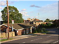
Eckington Friendship Club - Berry Avenue (NE Derbyshire)
Image: © Andrew Loughran
Taken: 3 Sep 2006
0.13 miles
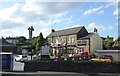
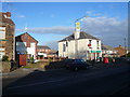
7
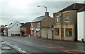
Houses and shop, West Street, Eckington
West Street becomes High Street further along. The shop is a newsagents. Seen from the end of Sitwell Street.
Image: © Andrew Hill
Taken: 30 May 2011
0.17 miles
8
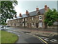
Terraced houses, High Street, Eckington
A row of houses seen from the corner of Berry Avenue.
Image: © Andrew Hill
Taken: 30 May 2011
0.18 miles
10
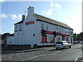
Convenience store, Eckington
On West Street.
Image: © JThomas
Taken: 28 Aug 2014
0.18 miles