IMAGES TAKEN NEAR TO
Ducksett Lane, SHEFFIELD, S21 4BS
Introduction
This page details the photographs taken nearby to Ducksett Lane, S21 4BS by members of the Geograph project.
The Geograph project started in 2005 with the aim of publishing, organising and preserving representative images for every square kilometre of Great Britain, Ireland and the Isle of Man.

There are currently over 7.5m images from over14,400 individuals and you can help contribute to the project by visiting https://www.geograph.org.uk
Image Map
Images are licensed for reuse under creativecommons.org/licenses/by-sa/2.0
Notes
- Clicking on the map will re-center to the selected point.
- The higher the marker number, the further away the image location is from the centre of the postcode.
Image Listing (52 Images Found)
Images are licensed for reuse under creativecommons.org/licenses/by-sa/2.0
Image
Details
Distance
1
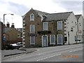
Angel Hotel, Eckington, NE Derbyshire.
The Angel is now boarded up.
Image: © Andrew Loughran
Taken: 28 Mar 2006
0.01 miles
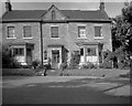
2
Southgate House 2007
In 2007 Southgate House was being used by Derbyshire Social Services after it had stopped being a children's home in the 1990s. I recollect that the large fir tree was planted in the 1980s and was an ex-Christmas Tree which then grew and grew and nobody did anything about it. Compare with Image taken from almost exactly the same viewpoint in 1962.
Image: © Andrew Tatlow
Taken: 9 Jul 2007
0.07 miles
3
Southgate House 1962
In 1963 Southgate House was sold to Derbyshire County Council for use as a children's home; it was used as a children's home for about 30 years.
This photograph was one of the first I took using my Kodak Brownie 44A given to me after it was won by my mother in one of the many competitions she entered.
Image: © Andrew Tatlow
Taken: Unknown
0.07 miles
4
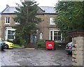
The Grange, Southgate, Eckington in NE Derbyshire.
Image: © Andrew Loughran
Taken: 10 Feb 2006
0.07 miles
5
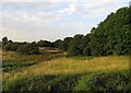
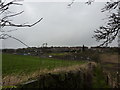
Fields by Staveley Lane
These fields were well grazed by cattle and horses 50 years ago and were part of the Sitwell Estate. Presumably they are now the next target for more houses as the field behind the photographer is now a housing estate.
Image: © Andrew Tatlow
Taken: 25 Jul 2019
0.08 miles
6
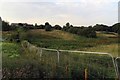
Footpath from Staveley Lane to Ducksett Lane
It was too late to investigate whether or not the footpath was still passable somewhere on the other side of the fences.
Image: © Andrew Tatlow
Taken: 25 Jul 2019
0.08 miles
8
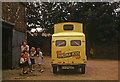
Turner's Ice Cream
One of my big brothers had a holiday job with Turner's Ice Cream of Mosborough. He called in at home when he needed a break during the day which was very popular with myself and the neighbours' children. In the picture are my mother and children of 2 of our neighbours. Ice cream was served by the scoop from dry ice freezers (which could not cope with very hot weather). No chimes, the ice cream man had a piercing whistle to blow. My brother was very popular, much to the annoyance of the opposition, as he would do magic tricks including occasionally finding 3d behind a child's ear if they had no money for a cornet! This was one of the "new" vans operated by Turners made in the 1950s. The "old" vans were from about 1930 and had the accelerator pedal between the brake and clutch.
Image: © Andrew Tatlow
Taken: Unknown
0.10 miles
9
Field, allotments and semis
To the south of Eckington, by a footpath leading off the B6053.
Image: © Peter Barr
Taken: 2 Jan 2013
0.10 miles
10
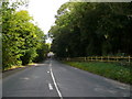
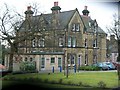
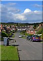
Staveley Lane
Looking downhill towards Station Road. The Coldwell Plantation (part of the Renishaw Hall Estate) is on the right of picture.
Image: © Alan Heardman
Taken: 2 Oct 2007
0.11 miles