IMAGES TAKEN NEAR TO
Chestnut Avenue, SHEFFIELD, S21 4BE
Introduction
This page details the photographs taken nearby to Chestnut Avenue, S21 4BE by members of the Geograph project.
The Geograph project started in 2005 with the aim of publishing, organising and preserving representative images for every square kilometre of Great Britain, Ireland and the Isle of Man.

There are currently over 7.5m images from over14,400 individuals and you can help contribute to the project by visiting https://www.geograph.org.uk
Image Map
Images are licensed for reuse under creativecommons.org/licenses/by-sa/2.0
Notes
- Clicking on the map will re-center to the selected point.
- The higher the marker number, the further away the image location is from the centre of the postcode.
Image Listing (26 Images Found)
Images are licensed for reuse under creativecommons.org/licenses/by-sa/2.0
Image
Details
Distance
1

Primitive Chapel, Eckington Marsh (1877)
Clearly the front extension is much newer than the original building with which it has been merged.
Image: © Neil Theasby
Taken: 23 Feb 2015
0.11 miles

3
Chesterfield Road, Eckington
Looking south west.
Image: © JThomas
Taken: 28 Aug 2014
0.12 miles
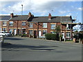
4
Top of Hornthorpe Road and houses on the main road
Hornthorpe Road is only surfaced for a short distance from the junction. The traffic lights are at the junction between Chesterfield Road and Dronfield Road.
Image: © Andrew Hill
Taken: 30 May 2011
0.13 miles
5
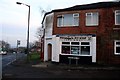
Penelope's Pit Stop
Takeaway food shop in Eckington
Image: © Graham Hogg
Taken: 11 Dec 2013
0.14 miles
7
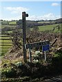
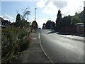
Countryside west of Eckington
Snowdrops have emerged beneath and around the street sign. Bolehill Lane leads westwards up to Marsh Lane.
Image: © Neil Theasby
Taken: 23 Feb 2015
0.14 miles
8

Old Village Signpost by the B6052, Chesterfield Road, Eckington village
No finial - 1 arm; by the B6052, in parish of Eckington (North East Derbyshire District), Chesterfield Road, South West approach to village.
To be surveyed
Milestone Society National ID: DE_SK4178
Image: © Milestone Society
Taken: Unknown
0.15 miles
9

Junction of Dronfield and Chesterfield Roads at Eckington
Image: © Chris Morgan
Taken: 11 Dec 2013
0.15 miles
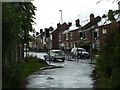
10
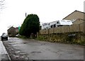
Eckington - Fenton Street (off Dronfield Rd)
View looking south along Fenton Street from the junction with Dronfield Road.
Image: © Andrew Loughran
Taken: 20 Jan 2006
0.16 miles