IMAGES TAKEN NEAR TO
Ash Crescent, SHEFFIELD, S21 4AD
Introduction
This page details the photographs taken nearby to Ash Crescent, S21 4AD by members of the Geograph project.
The Geograph project started in 2005 with the aim of publishing, organising and preserving representative images for every square kilometre of Great Britain, Ireland and the Isle of Man.

There are currently over 7.5m images from over14,400 individuals and you can help contribute to the project by visiting https://www.geograph.org.uk
Image Map
Images are licensed for reuse under creativecommons.org/licenses/by-sa/2.0
Notes
- Clicking on the map will re-center to the selected point.
- The higher the marker number, the further away the image location is from the centre of the postcode.
Image Listing (4 Images Found)
Images are licensed for reuse under creativecommons.org/licenses/by-sa/2.0
Image
Details
Distance
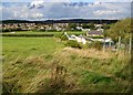
1

Approaching Marsh Farm
Unmade track near the southern outskirts of Eckington.
Image: © Jonathan Clitheroe
Taken: 21 May 2011
0.16 miles
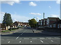
4

West End Pub, West Street, Eckington in NE Derbyshire
Image: © Andrew Loughran
Taken: 3 Sep 2006
0.24 miles