IMAGES TAKEN NEAR TO
Station Road, SHEFFIELD, S21 3WF
Introduction
This page details the photographs taken nearby to Station Road, S21 3WF by members of the Geograph project.
The Geograph project started in 2005 with the aim of publishing, organising and preserving representative images for every square kilometre of Great Britain, Ireland and the Isle of Man.

There are currently over 7.5m images from over14,400 individuals and you can help contribute to the project by visiting https://www.geograph.org.uk
Image Map (Loading...)


Getting Data...Please wait
Leaflet Map data © OpenStreetMap
Images are licensed for reuse under creativecommons.org/licenses/by-sa/2.0
Notes
- Clicking on the map will re-center to the selected point.
- The higher the marker number, the further away the image location is from the centre of the postcode.
Image Listing (50 Images Found)
Images are licensed for reuse under creativecommons.org/licenses/by-sa/2.0
Image
Details
Distance
1
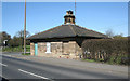
Tollhouse by the A6135, Station Road, Renishaw
Tollhouse by the A6135, in the parish of Eckington (North East Derbyshire District), No. 31, Station Road, Renishaw, S21 3WF.
Grade II listed.
List Entry Number: 1335097 https://historicengland.org.uk/listing/the-list/list-entry/1335097
Surveyed
Milestone Society National ID: DE.ECK
Image: © Alan Rosevear
Taken: 29 Mar 2009
0.01 miles
2
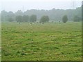
Water Meadow, Renishaw
The meadow lies just north of the Sitwell Arms Hotel directly to the east of the road to Eckington. Prone to flooding in autumn and winter.
Image: © Tim Marchant
Taken: 4 Sep 2005
0.01 miles
3
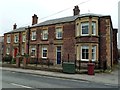
Former constabulary and courthouse
Now private residences, the carved stones above the doors show the buildings' original use.
Image: © Graham Hogg
Taken: 28 Feb 2012
0.03 miles
5
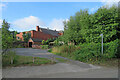
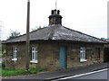
Renishaw: an overgrown footpath
The fingerpost on the right points along a short path which cuts the corner of Spinkhill Lane and Station Road - but the path is weed-choked and impassable. The red-brick building is the former police station shown in Image
Image: © John Sutton
Taken: 21 Aug 2022
0.04 miles
6
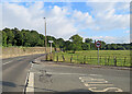
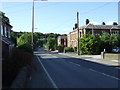
Renishaw: the corner of Spinkhill Lane
The A6135 to Eckington and on to Sheffield is on the left, Spinkhill Lane on the right.
Image: © John Sutton
Taken: 21 Aug 2022
0.04 miles
7
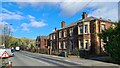
Old police station and Court House, Renishaw
Image: © Chris Morgan
Taken: 23 Feb 2022
0.05 miles
8
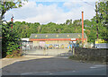
Renishaw: Yellow Machinery
Yellow Machinery, a plant and machinery hire company, is based in the former goods yard of Eckington & Renishaw station, on the Midland line from Chesterfield to Sheffield and Rotherham. The station closed long ago, but the large stone building in the centre of the picture is the former goods warehouse. There was another station nearby, Renishaw Central, on the Great Central main line. That too closed in the 1960s and nothing remains of it.
Image: © John Sutton
Taken: 21 Aug 2022
0.05 miles
10
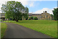
Renishaw: behind The Sitwell Arms Hotel
There is a large modern block of rooms behind the Victorian building which faces Station Road.
Image: © John Sutton
Taken: 21 Aug 2022
0.07 miles