IMAGES TAKEN NEAR TO
Field Avenue, SHEFFIELD, S21 3UN
Introduction
This page details the photographs taken nearby to Field Avenue, S21 3UN by members of the Geograph project.
The Geograph project started in 2005 with the aim of publishing, organising and preserving representative images for every square kilometre of Great Britain, Ireland and the Isle of Man.

There are currently over 7.5m images from over14,400 individuals and you can help contribute to the project by visiting https://www.geograph.org.uk
Image Map
Images are licensed for reuse under creativecommons.org/licenses/by-sa/2.0
Notes
- Clicking on the map will re-center to the selected point.
- The higher the marker number, the further away the image location is from the centre of the postcode.
Image Listing (23 Images Found)
Images are licensed for reuse under creativecommons.org/licenses/by-sa/2.0
Image
Details
Distance
1

Renishaw Village
View of Renishaw village from the North East, Spinkhill.
Image: © Tim Marchant
Taken: 2 Sep 2005
0.07 miles

3
Renishaw - Main Road
Junction with Smithy Bridge Road.
Image: © Alan Heardman
Taken: 25 Jan 2007
0.10 miles
4
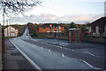
Main Road, Renishaw
Cars on what was formerly the A616, but is now the A6135, are using their lights on this gloomy November afternoon.
Image: © Stephen McKay
Taken: 11 Nov 2010
0.10 miles
5

Renishaw - Circular Drive Junction with Reynard Crescent
Image: © Alan Heardman
Taken: 26 Apr 2007
0.12 miles
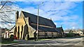
7
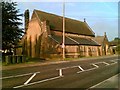
St Matthew's Church, Renishaw
Photo of the village church in Renishaw.
Image: © Tim Marchant
Taken: 1 Sep 2005
0.13 miles