IMAGES TAKEN NEAR TO
Ellisons Road, SHEFFIELD, S21 2JG
Introduction
This page details the photographs taken nearby to Ellisons Road, S21 2JG by members of the Geograph project.
The Geograph project started in 2005 with the aim of publishing, organising and preserving representative images for every square kilometre of Great Britain, Ireland and the Isle of Man.

There are currently over 7.5m images from over14,400 individuals and you can help contribute to the project by visiting https://www.geograph.org.uk
Image Map
Images are licensed for reuse under creativecommons.org/licenses/by-sa/2.0
Notes
- Clicking on the map will re-center to the selected point.
- The higher the marker number, the further away the image location is from the centre of the postcode.
Image Listing (30 Images Found)
Images are licensed for reuse under creativecommons.org/licenses/by-sa/2.0
Image
Details
Distance
5
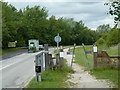
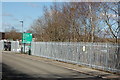
Entrance to Rother Valley Country Park
There is a parking charge for vehicles accessing the park beyond this point.
Image: © Andrew Hill
Taken: 17 Jun 2011
0.11 miles
6
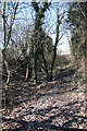
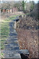
Disused Chesterfield Canal
Long-disused and overgrown stretch of the Chesterfield Canal at Norwood
Image: © Richard Croft
Taken: 8 Mar 2010
0.12 miles
8
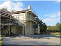
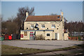
The Angel Inn at Norwood
Viewed from the south.
Image: © Peter Wood
Taken: 7 Sep 2014
0.14 miles
9
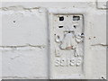
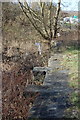
Ordnance Survey Flush Bracket S9135
This can be found on the wall of the former Angel Inn at Norwood,
For more detail see : http://www.bench-marks.org.uk/bm19203
Image: © Peter Wood
Taken: 7 Sep 2014
0.14 miles
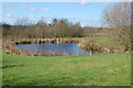
10
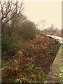
The Angel
Pub beside the disused Chesterfield Canal at Norwood
Image: © Richard Croft
Taken: 8 Mar 2010
0.14 miles