IMAGES TAKEN NEAR TO
Campion Drive, SHEFFIELD, S21 1TG
Introduction
This page details the photographs taken nearby to Campion Drive, S21 1TG by members of the Geograph project.
The Geograph project started in 2005 with the aim of publishing, organising and preserving representative images for every square kilometre of Great Britain, Ireland and the Isle of Man.

There are currently over 7.5m images from over14,400 individuals and you can help contribute to the project by visiting https://www.geograph.org.uk
Image Map
Images are licensed for reuse under creativecommons.org/licenses/by-sa/2.0
Notes
- Clicking on the map will re-center to the selected point.
- The higher the marker number, the further away the image location is from the centre of the postcode.
Image Listing (92 Images Found)
Images are licensed for reuse under creativecommons.org/licenses/by-sa/2.0
Image
Details
Distance
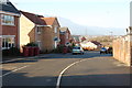
2
Junction Rowan Tree Road & Campion Drive
Image: © John Jennings
Taken: 30 Jan 2012
0.04 miles
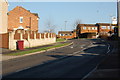
6
Houses between the embankments
The embankment of the former Chesterfield Canal is low but that behind the houses of the former Lancashire, Derbyshire and East Coast Railway is rather more substantial.
Image: © Jonathan Thacker
Taken: 5 Feb 2016
0.09 miles
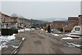
7
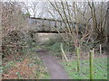
Railway bridge over the Chesterfield Canal
The bridge belonged to the Lancashire Derbyshire and East Coast Railway and ceased to be used in 1984.
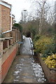
Beyond the bridge the line of the canal is clear to see though filled with vegetation rather than water. This side of the bridge the canal has been in-filled and is incorporated into a paddock. The footpath marks the line of the towpath.
Image: © Jonathan Thacker
Taken: 5 Feb 2016
0.09 miles
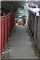
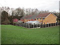
8
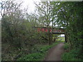
Disused railway over a disused canal
The Cuckoo Way is in use!
Image: © John Slater
Taken: 14 Apr 2012
0.09 miles