IMAGES TAKEN NEAR TO
Aspen Close, SHEFFIELD, S21 1TA
Introduction
This page details the photographs taken nearby to Aspen Close, S21 1TA by members of the Geograph project.
The Geograph project started in 2005 with the aim of publishing, organising and preserving representative images for every square kilometre of Great Britain, Ireland and the Isle of Man.

There are currently over 7.5m images from over14,400 individuals and you can help contribute to the project by visiting https://www.geograph.org.uk
Image Map
Images are licensed for reuse under creativecommons.org/licenses/by-sa/2.0
Notes
- Clicking on the map will re-center to the selected point.
- The higher the marker number, the further away the image location is from the centre of the postcode.
Image Listing (59 Images Found)
Images are licensed for reuse under creativecommons.org/licenses/by-sa/2.0
Image
Details
Distance
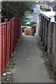
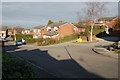
1
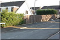
Junction Chestnut Avenue & Almond Drive
Image: © John Jennings
Taken: 30 Jan 2012
0.04 miles
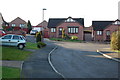
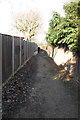
3
Junction Rowan Tree Road & Campion Drive
Image: © John Jennings
Taken: 30 Jan 2012
0.07 miles
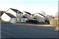
7
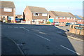
Junction Chestnut Avenue & Elder Court
Image: © John Jennings
Taken: 30 Jan 2012
0.08 miles
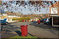
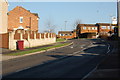
10
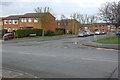
Junction Sheepcote Road & Marrison Drive
Image: © John Jennings
Taken: 2 Feb 2012
0.10 miles