IMAGES TAKEN NEAR TO
Gaunt Close, SHEFFIELD, S21 1SW
Introduction
This page details the photographs taken nearby to Gaunt Close, S21 1SW by members of the Geograph project.
The Geograph project started in 2005 with the aim of publishing, organising and preserving representative images for every square kilometre of Great Britain, Ireland and the Isle of Man.

There are currently over 7.5m images from over14,400 individuals and you can help contribute to the project by visiting https://www.geograph.org.uk
Image Map
Images are licensed for reuse under creativecommons.org/licenses/by-sa/2.0
Notes
- Clicking on the map will re-center to the selected point.
- The higher the marker number, the further away the image location is from the centre of the postcode.
Image Listing (117 Images Found)
Images are licensed for reuse under creativecommons.org/licenses/by-sa/2.0
Image
Details
Distance
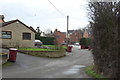

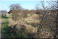
6

Link path from the Killamarsh Greenway
The Greenway is a path following the line of the Chesterfield Canal through the town.
Image: © Andrew Hill
Taken: 17 Jun 2011
0.05 miles

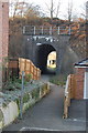
8
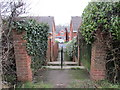
Steps down to Spooner Drive
From the embankment of the former Chesterfield Canal.
Image: © Jonathan Thacker
Taken: 5 Feb 2016
0.06 miles