IMAGES TAKEN NEAR TO
Hillside View, S21 1JZ
Introduction
This page details the photographs taken nearby to Hillside View, S21 1JZ by members of the Geograph project.
The Geograph project started in 2005 with the aim of publishing, organising and preserving representative images for every square kilometre of Great Britain, Ireland and the Isle of Man.

There are currently over 7.5m images from over14,400 individuals and you can help contribute to the project by visiting https://www.geograph.org.uk
Image Map
Images are licensed for reuse under creativecommons.org/licenses/by-sa/2.0
Notes
- Clicking on the map will re-center to the selected point.
- The higher the marker number, the further away the image location is from the centre of the postcode.
Image Listing (72 Images Found)
Images are licensed for reuse under creativecommons.org/licenses/by-sa/2.0
Image
Details
Distance
2
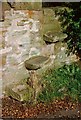
Steps Ashley Lane
These steps allow access to a footpath off Ashley Lane Killamarsh
Image: © John Jennings
Taken: 1 Jan 1992
0.05 miles
4
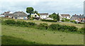
Fields by the eastern edge of Killamarsh
Looking across fields to houses on Ashley Lane.
Image: © Andrew Hill
Taken: 17 Jun 2011
0.07 miles
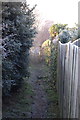
8
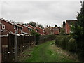
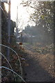
Footpath from Kirkcroft Lane to High Street
Between suburban houses.
Image: © Jonathan Thacker
Taken: 5 Feb 2016
0.10 miles
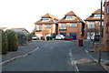
9
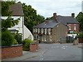
Ashley Lane, Church Town, Killamarsh
Looking down the street to The Crown Inn. The church is among the trees beyond.
Image: © Andrew Hill
Taken: 17 Jun 2011
0.11 miles