IMAGES TAKEN NEAR TO
Netherthorpe Close, SHEFFIELD, S21 1JS
Introduction
This page details the photographs taken nearby to Netherthorpe Close, S21 1JS by members of the Geograph project.
The Geograph project started in 2005 with the aim of publishing, organising and preserving representative images for every square kilometre of Great Britain, Ireland and the Isle of Man.

There are currently over 7.5m images from over14,400 individuals and you can help contribute to the project by visiting https://www.geograph.org.uk
Image Map
Images are licensed for reuse under creativecommons.org/licenses/by-sa/2.0
Notes
- Clicking on the map will re-center to the selected point.
- The higher the marker number, the further away the image location is from the centre of the postcode.
Image Listing (109 Images Found)
Images are licensed for reuse under creativecommons.org/licenses/by-sa/2.0
Image
Details
Distance
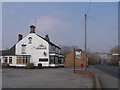
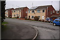
2
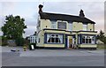
The Midland
A pub surviving in Killamarsh.
Image: © David Lally
Taken: 17 Sep 2016
0.03 miles
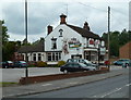
3
The Midland public house at Netherthorpe
Image: © John Slater
Taken: 10 Apr 2013
0.03 miles
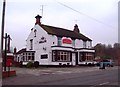
4
The Midland, Netherthorpe, Killamarsh
A pub on Sheffield Road by the junction with Walford Road.
Image: © Andrew Hill
Taken: 17 Jun 2011
0.03 miles
6
The Midland Public House in Killamarsh
This pub is situated on the B6058 Sheffield Road.
Image: © Jonathan Clitheroe
Taken: 14 Nov 2011
0.05 miles
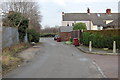
8
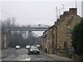
Killamarsh - terrace and viaduct on Sheffield Road
Image: © Dave Bevis
Taken: 11 Dec 2009
0.06 miles