IMAGES TAKEN NEAR TO
Crofters Close, SHEFFIELD, S21 1JH
Introduction
This page details the photographs taken nearby to Crofters Close, S21 1JH by members of the Geograph project.
The Geograph project started in 2005 with the aim of publishing, organising and preserving representative images for every square kilometre of Great Britain, Ireland and the Isle of Man.

There are currently over 7.5m images from over14,400 individuals and you can help contribute to the project by visiting https://www.geograph.org.uk
Image Map
Images are licensed for reuse under creativecommons.org/licenses/by-sa/2.0
Notes
- Clicking on the map will re-center to the selected point.
- The higher the marker number, the further away the image location is from the centre of the postcode.
Image Listing (34 Images Found)
Images are licensed for reuse under creativecommons.org/licenses/by-sa/2.0
Image
Details
Distance
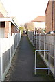
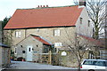
3
Boiley Lane
The lane leads down to the Rother valley from Westthorpe. Vehicle access for these houses and Boiley Farm only.
Image: © Andrew Hill
Taken: 17 Jun 2011
0.07 miles
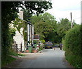
5
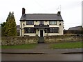
The West End Hotel
On Westthorpe Road, Killamarsh
Image: © Graham Hogg
Taken: 8 Mar 2021
0.10 miles
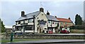
6

West End Hotel
At the junction of Crofters Close with Westthorpe Road.
Image: © Peter Barr
Taken: 11 Jul 2012
0.10 miles
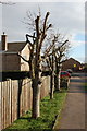
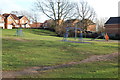
10
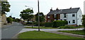
By Westthorpe Road
What looks like a traditional village with a green is now part of the southern side of Killamarsh.
Image: © Andrew Hill
Taken: 17 Jun 2011
0.13 miles