IMAGES TAKEN NEAR TO
Kirkcroft Avenue, SHEFFIELD, S21 1GX
Introduction
This page details the photographs taken nearby to Kirkcroft Avenue, S21 1GX by members of the Geograph project.
The Geograph project started in 2005 with the aim of publishing, organising and preserving representative images for every square kilometre of Great Britain, Ireland and the Isle of Man.

There are currently over 7.5m images from over14,400 individuals and you can help contribute to the project by visiting https://www.geograph.org.uk
Image Map
Images are licensed for reuse under creativecommons.org/licenses/by-sa/2.0
Notes
- Clicking on the map will re-center to the selected point.
- The higher the marker number, the further away the image location is from the centre of the postcode.
Image Listing (75 Images Found)
Images are licensed for reuse under creativecommons.org/licenses/by-sa/2.0
Image
Details
Distance
1
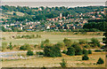
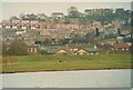
Killamarsh
Viewed from Rother Valley Country Park
Image: © John Jennings
Taken: 1 Sep 1991
0.02 miles
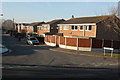
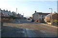
3
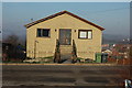
Old Methodist Chapel
Now a Private Dwelling
Image: © John Jennings
Taken: 16 Jan 2012
0.08 miles
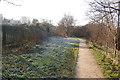
5
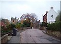
Kirkcroft Lane in Killamarsh
Looking east towards the Church of St Giles.
Image: © Jonathan Clitheroe
Taken: 14 Nov 2011
0.09 miles
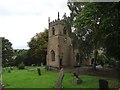
9
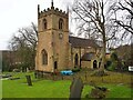
The Church of St Giles
Grade II* listed parish church dating from the 12th century
Image: © Graham Hogg
Taken: 8 Mar 2021
0.10 miles
10
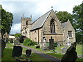
Church of St Giles, Killamarsh
The church is in a pretty setting at the edge of the town.
Image: © Andrew Hill
Taken: 17 Jun 2011
0.11 miles