IMAGES TAKEN NEAR TO
Walkers Lane, SHEFFIELD, S21 1ER
Introduction
This page details the photographs taken nearby to Walkers Lane, S21 1ER by members of the Geograph project.
The Geograph project started in 2005 with the aim of publishing, organising and preserving representative images for every square kilometre of Great Britain, Ireland and the Isle of Man.

There are currently over 7.5m images from over14,400 individuals and you can help contribute to the project by visiting https://www.geograph.org.uk
Image Map
Images are licensed for reuse under creativecommons.org/licenses/by-sa/2.0
Notes
- Clicking on the map will re-center to the selected point.
- The higher the marker number, the further away the image location is from the centre of the postcode.
Image Listing (79 Images Found)
Images are licensed for reuse under creativecommons.org/licenses/by-sa/2.0
Image
Details
Distance
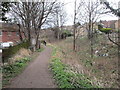
1
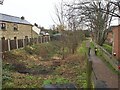
Abandoned section of the Chesterfield Canal in Killamarsh
Image: © Graham Hogg
Taken: 8 Mar 2021
0.02 miles
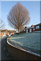
3
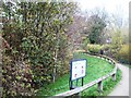
Line of Former Chesterfield Canal in Killamarsh
Footpath running alongside the route of the former canal in Killamarsh near Kirkcroft Lane. The sign next to the path describes the canal's history and plans for its future regeneration.
Image: © Jonathan Clitheroe
Taken: 14 Nov 2011
0.03 miles
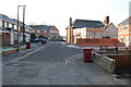
4
Chesterfield Canal, Killamarsh
Once upon a time, the Chesterfield Canal passed right through the middle of Killamarsh. Now sadly it's overgrown and in parts, built across. There are however plans to reinstate the canal using probably part of the Rother, making it possible once again to get from the Trent via Worksop to Chesterfield town centre. This picture shows the route of the canal as it crossed Bridge Street in Killamarsh, the canal running roughly east - west.
Image: © David Morris
Taken: 17 Sep 2005
0.03 miles
5
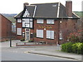
The Navigation. Killamarsh
Closed as a Pub now Offices
Image: © John Jennings
Taken: 11 Apr 2005
0.04 miles
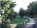
8
The Chesterfield Canal
Much of the canal in Killamarsh has been infilled but this short stretch west of Bridge Street hasn't though there is rather more vegetation than water.
Image: © Jonathan Thacker
Taken: 5 Feb 2016
0.05 miles
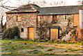
10
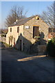
Former Slaughter House
Also was a warehouse for the canal. Now a private home.
Image: © John Jennings
Taken: 3 Feb 2012
0.06 miles