IMAGES TAKEN NEAR TO
Nethergreen Court, SHEFFIELD, S21 1EA
Introduction
This page details the photographs taken nearby to Nethergreen Court, S21 1EA by members of the Geograph project.
The Geograph project started in 2005 with the aim of publishing, organising and preserving representative images for every square kilometre of Great Britain, Ireland and the Isle of Man.

There are currently over 7.5m images from over14,400 individuals and you can help contribute to the project by visiting https://www.geograph.org.uk
Image Map
Images are licensed for reuse under creativecommons.org/licenses/by-sa/2.0
Notes
- Clicking on the map will re-center to the selected point.
- The higher the marker number, the further away the image location is from the centre of the postcode.
Image Listing (25 Images Found)
Images are licensed for reuse under creativecommons.org/licenses/by-sa/2.0
Image
Details
Distance
5
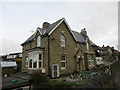
Lock House
Situated adjacent to the course of the former Chesterfield Canal.
Image: © Jonathan Thacker
Taken: 5 Feb 2016
0.18 miles
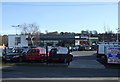
7
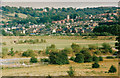
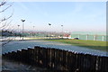
Killamarsh
Viewed from Rother Valley Country Park
Image: © John Jennings
Taken: 1 Sep 1991
0.18 miles
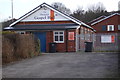
8
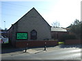
Killamarsh Methodist Church
On Sheffield Road (B6058).
Image: © JThomas
Taken: 7 Mar 2015
0.19 miles
10
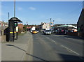
Bus stop and shelter on Sheffield Road (B6058)
Looking east.
Image: © JThomas
Taken: 7 Mar 2015
0.19 miles