IMAGES TAKEN NEAR TO
Colliery Drive, SHEFFIELD, S21 1DF
Introduction
This page details the photographs taken nearby to Colliery Drive, S21 1DF by members of the Geograph project.
The Geograph project started in 2005 with the aim of publishing, organising and preserving representative images for every square kilometre of Great Britain, Ireland and the Isle of Man.

There are currently over 7.5m images from over14,400 individuals and you can help contribute to the project by visiting https://www.geograph.org.uk
Image Map
Images are licensed for reuse under creativecommons.org/licenses/by-sa/2.0
Notes
- Clicking on the map will re-center to the selected point.
- The higher the marker number, the further away the image location is from the centre of the postcode.
Image Listing (56 Images Found)
Images are licensed for reuse under creativecommons.org/licenses/by-sa/2.0
Image
Details
Distance
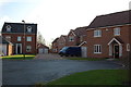
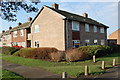
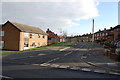
3
Houses round a square Westthorpe Road
Image: © John Jennings
Taken: 30 Jan 2012
0.06 miles
6
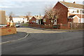
Junction Simcrest Avenue & Heath Avenue
Image: © John Jennings
Taken: 2 Feb 2012
0.08 miles
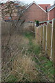
7
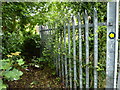
Footpath; impossible
Give this one a miss and move on to the next street; a derelict suburban path in Killamarsh.
Image: © Peter Barr
Taken: 11 Jul 2012
0.09 miles
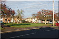
8
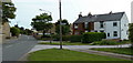
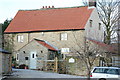
By Westthorpe Road
What looks like a traditional village with a green is now part of the southern side of Killamarsh.
Image: © Andrew Hill
Taken: 17 Jun 2011
0.11 miles
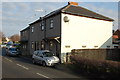
10
Junction Beech Crescent & Westfield Road
Image: © John Jennings
Taken: 2 Feb 2012
0.11 miles