IMAGES TAKEN NEAR TO
Farriers Way, SHEFFIELD, S21 1DE
Introduction
This page details the photographs taken nearby to Farriers Way, S21 1DE by members of the Geograph project.
The Geograph project started in 2005 with the aim of publishing, organising and preserving representative images for every square kilometre of Great Britain, Ireland and the Isle of Man.

There are currently over 7.5m images from over14,400 individuals and you can help contribute to the project by visiting https://www.geograph.org.uk
Image Map
Images are licensed for reuse under creativecommons.org/licenses/by-sa/2.0
Notes
- Clicking on the map will re-center to the selected point.
- The higher the marker number, the further away the image location is from the centre of the postcode.
Image Listing (65 Images Found)
Images are licensed for reuse under creativecommons.org/licenses/by-sa/2.0
Image
Details
Distance
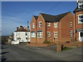
1
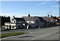
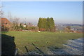
Farriers Way
These Flats and Houses were built on the site of The Blacksmiths Arms. photo number 2752464
Image: © John Jennings
Taken: 16 Jan 2012
0.02 miles
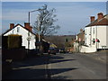
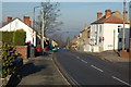
6
High Street, Killamarsh
The street climbs away from the town centre, and is largely residential.
Image: © Andrew Hill
Taken: 17 Jun 2011
0.06 miles
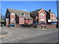
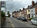
9
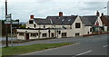
The Nag's Head
A pub at the junction of High Street / Upperthorpe Road and Westthorpe Road.
Image: © Andrew Hill
Taken: 17 Jun 2011
0.07 miles