IMAGES TAKEN NEAR TO
Ergo Park, Drake House Crescent, S20 7JP
Introduction
This page details the photographs taken nearby to Ergo Park, Drake House Crescent, S20 7JP by members of the Geograph project.
The Geograph project started in 2005 with the aim of publishing, organising and preserving representative images for every square kilometre of Great Britain, Ireland and the Isle of Man.

There are currently over 7.5m images from over14,400 individuals and you can help contribute to the project by visiting https://www.geograph.org.uk
Image Map
Images are licensed for reuse under creativecommons.org/licenses/by-sa/2.0
Notes
- Clicking on the map will re-center to the selected point.
- The higher the marker number, the further away the image location is from the centre of the postcode.
Image Listing (9 Images Found)
Images are licensed for reuse under creativecommons.org/licenses/by-sa/2.0
Image
Details
Distance
3
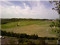
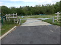
Linley Bank Meadow Nature Reserve
You're looking at a former refuse tip. Work has been going on for quite some time now to transform the site into a nature reserve. The site has been cleared and hundreds of trees have been planted. To the left you can just make out Shire Brook Nature Reserve
Image: © Darren Raynes
Taken: 23 Aug 2007
0.15 miles
4
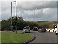
Roundabout with exit to Hackenthorpe on B6053
Image: © Neil Theasby
Taken: 2 Oct 2010
0.16 miles
5
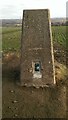
Beighton Trig Point in Farmer's Field
Image: © Darren Haddock
Taken: 15 Nov 2018
0.19 miles
6
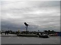
Drakehouse retail park art, flying ducks?
In the background the obligatory McDonald's.
Image: © Steve Fareham
Taken: 28 Jun 2011
0.21 miles
7
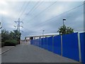
Building site at Drakehouse retail park
Behind the hoardings a new unit is being created complete with overhead high power lines.
Image: © Steve Fareham
Taken: 28 Jun 2011
0.22 miles
9
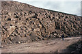
A57 road cutting under construction in Woodhouse Rock Sandstone
This is the cutting excavation for what is now the A57 dual carriageway Beighton bypass, south-east Sheffield. The rock face in the picture is made of well-jointed Woodhouse Rock, a sandstone unit in the Coal Measures (upper Carboniferous).
We spent a happy hour measuring rock joints and fracture orientations to form a teaching/research data set.
Photo taken with a Zenit E camera on Kodachrome 64 transparency film
Image: © S Dumpleton
Taken: 1 Jan 1993
0.22 miles