IMAGES TAKEN NEAR TO
Clayton Crescent, SHEFFIELD, S20 7HN
Introduction
This page details the photographs taken nearby to Clayton Crescent, S20 7HN by members of the Geograph project.
The Geograph project started in 2005 with the aim of publishing, organising and preserving representative images for every square kilometre of Great Britain, Ireland and the Isle of Man.

There are currently over 7.5m images from over14,400 individuals and you can help contribute to the project by visiting https://www.geograph.org.uk
Image Map
Images are licensed for reuse under creativecommons.org/licenses/by-sa/2.0
Notes
- Clicking on the map will re-center to the selected point.
- The higher the marker number, the further away the image location is from the centre of the postcode.
Image Listing (17 Images Found)
Images are licensed for reuse under creativecommons.org/licenses/by-sa/2.0
Image
Details
Distance
1
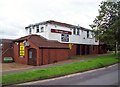
The Hawk and Dove Public House
Public house situated on Thorpe Green in Waterthorpe.
Image: © Jonathan Clitheroe
Taken: 17 Jul 2012
0.13 miles
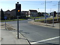
2
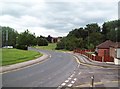
Ochre Dike Lane near Crystal Peaks
Street scene in the Waterthorpe area of Sheffield. Purbeck Road joins Ochre Dike Lane on the right of picture.
Image: © Jonathan Clitheroe
Taken: 17 Jul 2012
0.14 miles
3
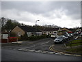
Purbeck Road, Waterthorpe
A bungalow lined road off Ochre Dike Lane (foreground) in Waterthorpe. Crystal Peaks shopping centre is a short distance behind the photographer.
Image: © Richard Vince
Taken: 27 Apr 2013
0.15 miles
4
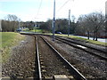
Tramway near Crystal Peaks Shopping Centre
Looking south east.
Image: © JThomas
Taken: 7 Mar 2015
0.16 miles
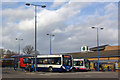
6
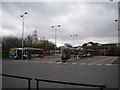
Crystal Peaks bus station
This bus station is attached to the west end of Crystal Peaks shopping centre, an important retail and transport hub in Sheffield's south eastern suburbs. The building in the background towards the right is a large pub restaurant.
Image: © Richard Vince
Taken: 27 Apr 2013
0.20 miles
7
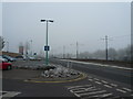
Crystal Peaks - Leaving the Car Park on a Cold Winter's Day
The supertram track can be seen on the right hand side of the picture.
Image: © Alan Heardman
Taken: 19 Feb 2008
0.20 miles
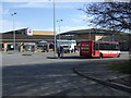
9
Crystal Peaks Bus Station
The bus station serves Crystal Peaks shopping centre. The bus in the foreground is operating a cross-city Fulwood - Halfway service.
Image: © Stephen McKay
Taken: 12 Mar 2008
0.21 miles
10
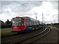
Tram approaching Crystal Peaks tram stop
A tram negotiates the sharp bend to Crystal Peaks tram stop, on its way from Halfway to Malin Bridge via Sheffield city centre.
Image: © Richard Vince
Taken: 27 Apr 2013
0.22 miles