IMAGES TAKEN NEAR TO
Thorpe Green, SHEFFIELD, S20 7HH
Introduction
This page details the photographs taken nearby to Thorpe Green, S20 7HH by members of the Geograph project.
The Geograph project started in 2005 with the aim of publishing, organising and preserving representative images for every square kilometre of Great Britain, Ireland and the Isle of Man.

There are currently over 7.5m images from over14,400 individuals and you can help contribute to the project by visiting https://www.geograph.org.uk
Image Map
Images are licensed for reuse under creativecommons.org/licenses/by-sa/2.0
Notes
- Clicking on the map will re-center to the selected point.
- The higher the marker number, the further away the image location is from the centre of the postcode.
Image Listing (5 Images Found)
Images are licensed for reuse under creativecommons.org/licenses/by-sa/2.0
Image
Details
Distance
1
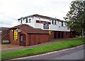
The Hawk and Dove Public House
Public house situated on Thorpe Green in Waterthorpe.
Image: © Jonathan Clitheroe
Taken: 17 Jul 2012
0.01 miles
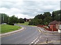
2
Purbeck Road, Waterthorpe
A bungalow lined road off Ochre Dike Lane (foreground) in Waterthorpe. Crystal Peaks shopping centre is a short distance behind the photographer.
Image: © Richard Vince
Taken: 27 Apr 2013
0.20 miles
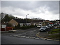
3
Ochre Dike Lane near Crystal Peaks
Street scene in the Waterthorpe area of Sheffield. Purbeck Road joins Ochre Dike Lane on the right of picture.
Image: © Jonathan Clitheroe
Taken: 17 Jul 2012
0.21 miles
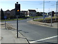
4
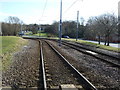
Tramway near Crystal Peaks Shopping Centre
Looking south east.
Image: © JThomas
Taken: 7 Mar 2015
0.22 miles