IMAGES TAKEN NEAR TO
Moorthorpe View, SHEFFIELD, S20 6QE
Introduction
This page details the photographs taken nearby to Moorthorpe View, S20 6QE by members of the Geograph project.
The Geograph project started in 2005 with the aim of publishing, organising and preserving representative images for every square kilometre of Great Britain, Ireland and the Isle of Man.

There are currently over 7.5m images from over14,400 individuals and you can help contribute to the project by visiting https://www.geograph.org.uk
Image Map
Images are licensed for reuse under creativecommons.org/licenses/by-sa/2.0
Notes
- Clicking on the map will re-center to the selected point.
- The higher the marker number, the further away the image location is from the centre of the postcode.
Image Listing (7 Images Found)
Images are licensed for reuse under creativecommons.org/licenses/by-sa/2.0
Image
Details
Distance
2
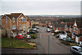
Moorthorpe Rise
Modern houses at Owlthorpe
Image: © Richard Croft
Taken: 13 Feb 2011
0.08 miles
3
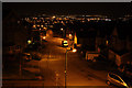
Moorthorpe Rise
Night view of Moorthorpe Rise http://www.geograph.org.uk/photo/2277057 and the lights of Sheffield suburbs beyond
Image: © Richard Croft
Taken: 13 Feb 2011
0.09 miles
4
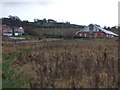
Moorhole.
Looking across the wilderness of a brown field site.
Image: © John Poyser
Taken: 5 Jan 2007
0.13 miles
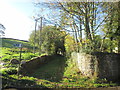
5
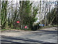
Moorhole Lane
Lane off Moor Valley (A6135) towards Owlthorpe.
Image: © JThomas
Taken: 7 Mar 2015
0.19 miles
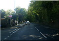
6
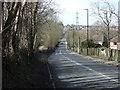
Moor Valley (A6135)
Heading north west towards Sheffield City Centre.
Image: © JThomas
Taken: 7 Mar 2015
0.21 miles